This Map Shows California's Potential to Power Itself With Clean Energy
An Oklahoma firm has produced a map showing the regional energy scenes across the United States, and the results are interesting -- though some of what's going on in California doesn't really show.
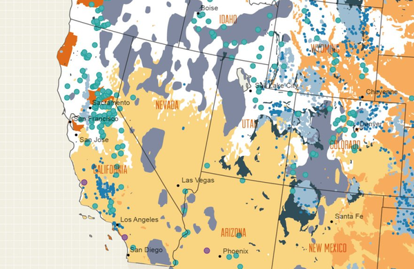
The map, drawn to show the available energy resources in different regions across the U.S., reveals that California is relatively rich in renewable energy potential. Foremost among the forms of renewable energy resource covering the state is solar, represented on the map by the light yellow wash across the southern two-thirds of the state.
Competing for second place in California's potential renewable resources -- at least on a broad geographic scale -- are hydroelectric power, with major existing facilities represented by the teal circles on the map, and geothermal, shown in charcoal. A few Northern California counties show exceptional promise for biomass power, and they're shown in Golden Gate Bridge orange.
Perhaps surprisingly, given its newsworthiness in the state these days, wind power doesn't loom large on the map: it's shown mainly in currently developed wind resource areas such as Tehachapi and San Gorgonio Pass, the tiny medium orange patches lost in a sea of solar yellow.
According to Saxum, California stil takes third place in wind power capacity, after Texas and Iowa. The Golden State's the front-runner in solar and geothermal development, and in second place in hydro and biomass behind Washington State and Florida, respectively.
You can also see more conventional energy mapped here: natural gas fields are a pale gray mainly found in the Sacramento Valley, oil wells are mapped as blue dots in Kern and Los Angeles counties, and nuclear power plants are violet circles. So the map's a week or so out of date there.
Over at the Berkeley Energy and Resources Collaborative blog, Patrick Donnelly-Shores points out an interesting conclusion to draw from the whole map. Here's the whole thing (click to enlarge in a new window):
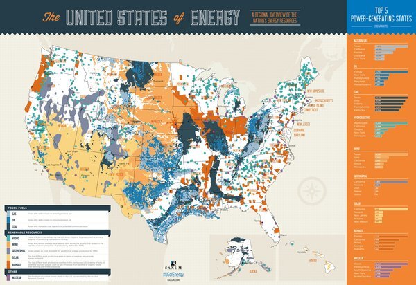
The map, says Donnelly-Shores, "reveals a nation whose energy production is concentrated in specific areas, mostly in the wide open spaces of the Intermountain West. And yet the majority of energy consumption occurs in the coastal states, population centers like the D.C.-Boston megalopolis and the large urban areas of Southern California."
In those populated parts of the country, energy extraction -- whether conventional or renewable -- is often extremely controversial. Donnelly-Shores uses both California desert solar and fracking in New York and Pennsylvania as examples. Meanwhile, in the less-populated interior states, energy extraction often proceeds with little regard paid to its environmental impacts. "[W]hile the debates rage about utility-scale solar plants in the California desert," he concludes, "the real action on the energy front is in the Intermountain West, where energy extraction dominates the local discourse, while the rest of the nation waits to receive its remotely generated power."
(Donnelly-shores, incidentally, has started a new blog to discuss utility-scale solar on a global scale. ReWire notes this as something between full disclosure and a free plug: Said new blog, Miracle or Mirage?, is part of a network of nature blogs founded by ReWire's host. We'd encourage you to check it out even if it wasn't.)


