


How SoCal's Automobile Club Paved the Way For Road Development in the Name of Historic Preservation

This story is part of a series about the Automobile Club of Southern California's role in road development and the club's relationship with environmental and historic preservation. Read the first article in the series which recounts how the automobile club ushered car-friendly access to our National Parks.
At the close of the 19th century, Los Angeles was keen to make a name for itself on a national scale. In 1895, California governor Henry Markham publicly expressed the need for his state to enter the Good Roads Movement, an initiative undertaken in the early 1890s by bicyclists advocating for urban road construction that had been transforming the East Coast. Los Angeles-based business syndicates formed in the 1880s and '90s, including the Los Angeles Chamber of Commerce and the Merchants and Manufacturers Association, had been working tirelessly to stimulate that movement by publicizing Los Angeles County as a region composed equally of a romantic Spanish past and plenty of room for modern industry.
Amid this backdrop, ten Los Angeles-based businessmen came together in 1900 to establish the Automobile Club of Southern California, which is now affiliated with the American Automobile Association. They did not set out to create yet another boosterish organization. Instead, they had envisioned a private social club through which they could race their horseless carriages among themselves while foreseeing an opportunity to increase the value of the local real estate assets owned by its board of directors. However, it would soon rebrand itself as a public-oriented organization dedicated to the improvement and regulation of the infrastructure of Los Angeles, a city that had not yet embraced the automobile, in order to transform it into the economic center of the western United States. Through efforts that included land surveying, signposting, mapmaking, marketing and lobbying for road infrastructure and related forms of construction, its members defined their organization as "the friend to all motorists" — a motto it would later include in all published materials.
The club first expressed an attentiveness to public interest by championing historic preservation efforts within the Western United States. In addition to the fact that protecting the nation's architectural past had become a matter of growing concern for the American public during the early 20th century, the ability to demonstrate that the region had a cultural past was thought to attract Eastern families and businessmen, who had otherwise been weary of investing in the relatively undeveloped West Coast.
![Photograph looking south on Sepulveda Boulevard at Chatsworth Road showing inlets to culverts on east and west sides of Sepulveda Boulevard, Los Angeles. Also visible are: open lands, wooden guard rails, signs, palm tree, bell, stand of other trees (at left), automobiles, buildings barely visible in distance, railroad tracks, utility poles and lines, bench. Legible signs include: "El Camino Real, Mission San Fernando [...] [arrow], [arrow] Los Angeles Plaza 24, Auto Club of So. Cal.", "[arrow] [...] Santa [...] Pass, San Fernando [...], Burbank [...], Glendale [...] [arrow], Auto Club of So. Cal."](https://kcet.brightspotcdn.com/dims4/default/0634e0c/2147483647/strip/true/crop/1139x665+0+0/resize/848x495!/quality/90/?url=http%3A%2F%2Fkcet-brightspot.s3.us-east-1.amazonaws.com%2F3e%2F42%2Fa6e5d07b4fb4ab3880dbc372ced6%2Ffigure-3-1.jpg)

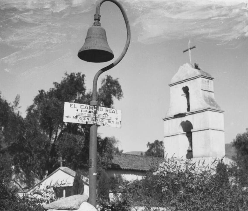
In 1904, the Auto Club president and director Dr. Milbank Johnson presided over the first Camino Real convention, a meeting organized by the Chamber of Commerce to hammer out the details for transforming a supposed 600-mile walking path connecting the 21 California Missions, known as El Camino Real ("The King's Highway"), into the state's first automobile highway. Despite several contemporary journalists debunking the myth of the well-trodden path, the Auto Club collaborated with the El Camino Real Association in 1906 to design Mission Bell guideposts with the intention of setting them a mile apart along the entire highway.
After requesting seed money from individuals and booster clubs alike, the Auto Club installed the first guidepost in 1906 in front of the Plaza Church (which, despite being adorned with bells along its facade, was not one of the California Missions) in downtown Los Angeles. Beneath the bell, the club placed a sign with arrows pointing to the two nearest missions, allowing travelers to take in several historic sites in a single afternoon (if, of course, they had the proper mode of transportation). Over the following eight years, they installed more than 400 additional bells between San Diego and the Bay Area, conveniently placing Los Angeles at the center of a roadway connecting Northern and Southern California.

During the process, the club's monthly magazine, "Touring Topics," regularly featured photographs of visitors arriving at the weathered missions in relatively immaculate automobiles via newly paved roads funded by California taxpayers. In 1914, the bell installation project had been considered a great enough success for the Auto Club to adopt the iconic Mission Bell as their own emblem — a relic of the organization's past that remains to this day.
That same year, the Auto Club set their sights eastward through a collaboration with the National Old Trails Road Association, an organization formed in Kansas City to develop an automobile highway from New York City to Los Angeles that would additionally connect motorists with several historic east-west trails of Pioneer-era fame, including the Santa Fe Trail and the National Road. From the perspective of the Auto Club, the construction of the National Old Trails Road, also known as the Ocean-to-Ocean Highway, was an opportunity to physically connect their growing city with the long-established economic powers of the East Coast.
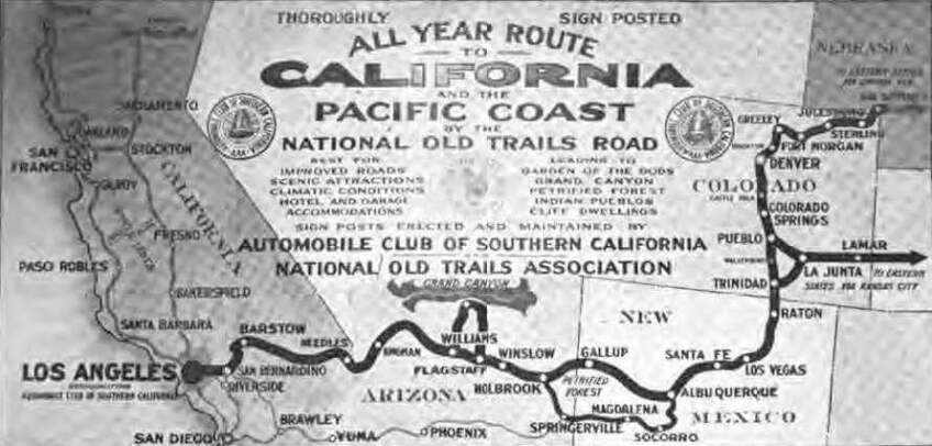

They began by sending their chief engineer O.K. Parker on a drive to the midway point in Kansas City to provide an initial inspection of the road conditions before commissioning field representative C.H. McStay to precisely chart the nearly 2,000-mile-long route in a matter of only nine weeks. Like their efforts along El Camino Real, the club made their assistance in the transnational project known by installing thousands of signposts along the entirety of the route between Los Angeles and Kansas City, each one donning the words "AUTO CLUB SO. CAL" along the bottom edge.
In 1916, several years before the western half of the Old Trails Road would be fully paved with asphalt, the Auto Club published a book of 37 'strip' maps detailing every step of the way from Los Angeles to Kansas City. The idyllic illustration on the cover — a meandering trail leading to a vaguely Adobe-style building reminiscent of New Mexico's historic Taos Pueblo — belied the fast-paced and heavily modernized automobile road that would pass through the region. Ten years later, a major portion of the western half of the Old Trails Road would become itself a historic object of American history when it was incorporated into U.S. Route 66, otherwise known as the Main Street of America and the Mother Road.

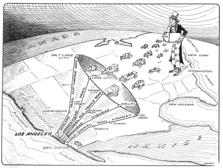
Prior to the population boom Los Angeles enjoyed in the 1920s, the Auto Club assisted in lobbying, charting and signposting projects for several other roadways with historic ties, including the Arrowhead Trail, Lincoln Highway and the Old Spanish Trail Highway. An illustration from the February 1920 issue of Touring Topics depicted scores of East Coast motorists heading toward Southern California via one of several historically-themed roads (collectively represented as a funnel) with Uncle Sam following closely behind with a suitcase. As each of these projects claimed to bring tourists into closer contact with their nation's patchwork of historic sites, they would also disproportionately facilitate national automobile access to and from Los Angeles as the newest and most quickly developing metropolis in the nation.
Additional Reading
Kropp, Phoebe Schroeder. California Vieja: Culture and Memory in a Modern American Place. Berkeley, Calif.: University of California Press, 2008.
"From Names to Numbers: The Origins of the U.S. Numbered Highway System - General Highway History - Highway History - Federal Highway Administration." https://www.fhwa.dot.gov/infrastructure/numbers.cfm.
Vogel, Andrew. "Hamlin Garland's Roads, the Good Roads Movement, and the Ambivalent Reform of America's Geographic Imagination." Studies in American Naturalism 5, no. 2 (2010): 111–32.


