PLAN-O-poly: How Do You Envision Your Riverfront District?
The NELA Riverfront Collaborative is an interdisciplinary project that builds upon the growing momentum of efforts already underway to transform the Los Angeles River into a "riverfront district" and to create a focal point of community revitalization. KCET Departures is the media partner of the Northeast Los Angeles Riverfront Collaborative. For more information visit the website www.mylariver.org
On Saturday July 13, 2013, the NELA Riverfront Collaborative held their first Summer Policy Engagement workshop, which focused on placemaking along the Northeast Los Angeles stretch of the Los Angeles River. The event, held at the Cypress Park Library was attended by over one hundred community stakeholders, each excited to contribute their expertise on their neighborhoods, and their vision for creating a successful riverfront district.
Placemaking is a collaborative process that can be extraordinarily effective in making people feel attached to the places where they live, work and play. When community stakeholders are involved in placemaking, they are more likely to get involved and invested in their communities.
As a City Planner for the City of Los Angeles, I was most interested in understanding the community's priorities for placemaking: What are the types of uses, recreational activities, public facilities and quality of life features that community members feel would improve their community, and where should those uses, activities and features be located?
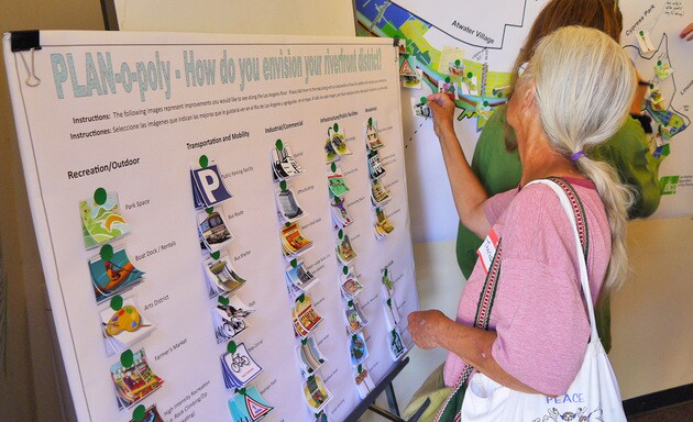
In order to encourage participation, I developed a game, PLAN-o-poly, which included a large zoning map of the riverfront area, which was the game board, and 40 colorful "play pieces" with icons representing a variety of River-related uses and amenities. The community members were allowed to place as many "play pieces" on the map as they wished, however they were required to describe how each addition would improve their community.

The goal of the placemaking game was to get stakeholders thinking about the social and infrastructural gaps, and potential opportunities for growth within their community as they interacted with one another. As the game progressed, community members began to have poignant discussions of the negative and positive attributes of their community.
The game started with the placement of what would be the most popular icon, "Park Space," half of which were placed within the Griffith Park Area. Residents lamented over how the River, as well as their communities, were so poorly connected to Griffith Park. Some residents thought pedestrian bridges with bike access over the River, and also over the 5 freeway, would improve connections. The second most popular area for "Park Space" was along the Taylor Yards site, adjacent to the Sonia Sotomayor Learning Academies and Rio De Los Angeles State Park. Community members opined of the need to connect other valuable community resources to the River, creating a synergy between them. One resident commented that investments that connect children to the River will build a sense of civic engagement and pride early in their youth that develops as they age. She continued that "a community with a sense of civic investment and pride is a place that the private sector, federal government, and local agencies feel compelled to invest, because their investments will be appreciated and maintained through the years."
More on community engagement through placemaking


While the increase of outdoor space came as no surprise to me, some additions to the map that were surprising were the placement of boutique hotels, restaurants, office space, community retail, and higher density housing within the commercial areas directly adjacent to the River in Elysian Valley, between the 2 freeway and Dorris Place. Currently that area is zoned for Industrial uses, and developed with a haphazard assortment of commercial and some industrial uses that range from a high end architecture and design studio, to auto dismantling facilities.

As the community members discussed this region, they identified the need for an organized commercial district with uses that are respectful and environmentally sensitive to the River, and also integrative of the adjacent communities, allowing visual and pedestrian access to the Los Angeles River. Encouraging more suitable uses that provide better visual and pedestrian access into the River will increase safety, property values, and civic awareness of the River, thereby promoting its maintenance and well-being. One community member poetically commented, "If you call it a flood control channel then it will only be a flood control channel, but if you call it river, people will treat it like a river ... and that will only happen if you can see it, smell it and hear it roar from your homes, while you shop, as you exercise and live your life."
The Los Angeles Department of City Planning is currently working on a Riverfront Vision Plan for the Los Angeles River within the Northeast Los Angeles Community, which includes portions of Elysian Valley, Atwater Village, Glassell Park, Cypress Park and Lincoln Heights. The Visioning Process includes several components, one of which is placemaking. The goal is to look at placemaking as a critical tool of community building and thereby economic development.
The purpose of the Vision Plan is to provide a shared community-wide vision framework that informs elected officials along with various City, State and Federal agencies of future economic and recreational River investment priorities. This Vision Plan will recommend specific action steps and lay a preliminary implementation timeline for recommended catalytic development projects and innovative policy directives. Within this document, the Department of City Planning will consider zoning refinements, neighborhood stabilization techniques, economic sustainability plans, urban design standards and methods to increase River access points and improve mobility linkages as a means to meeting the contemporary needs and anticipate future demographic trends of the Los Angeles River and the Northeast Los Angeles Community.
The Department of City Planning expects to take the Vision Plan to City Planning Commission by the Spring of 2014.


