A Brief Guide to 15 of San Diego County's Coastal Nature Preserves


This guide is part of KCET's California Coastal Trail project, which looks at the state's massive undertaking to build a trail over 1,000 miles in length along its whole coastline.
The San Diego Coast runs from the border fence to the hulking remains of the San Onofre Nuclear Power plant, with tony towns like La Jolla and Del Mar between, so you might assume that there isn't a whole lot of nature left. And we've certainly lost a lot of the natural San Diego coast.
But these 15 nature preserves, operated by a range of different agencies, offer a still-compelling cross section of the range of nature to be found along the county's coast.
Some of these preserves are part of multi-use parks, where your nature watching may take place with a backdrop of basketball games and picnicking families. Others are devoted entirely to the pursuit of nature study, and in (at least one) case, entry is limited so you may be doing your watching from the edges. But all of them offer a glimpse of the San Diego coast that was, and hope for the coast yet to come -- if we preserve them carefully.
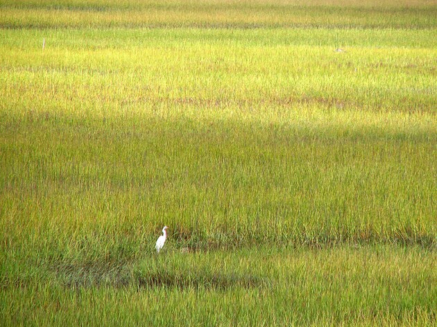
Tijuana River

The Tijuana River Valley Regional Park, part of the San Diego County Parks and Recreation department's network of protected lands, offers more than 22 miles of trails through 1,800 acres of landscape In Imperial Beach hard against the national border, a mile or two inland from the ocean. Here, you can explore the riparian forest that once extended for miles on both sides of the Tijuana River, or take in the view from coastal sage scrub-covered mesas.
Two dozen sensitive species call this park home, and more than 300 species of resident and migrating birds have been documented here. The Regional Park is a great place to watch migrating butterflies as well -- some of which likely avail themselves of blooming vegetable plants at the park's community garden area.
That's right: this park is a mix of nature appreciation and recreation, with the aforementioned garden, a large sports field complex, along with horse trails and a picnic area.
Between the Regional Park and the Pacific, a complex of reserves and parks operated by a handful of agencies offer opportunities to study and appreciate the Tijuana River's outflow to the sea. The Tijuana River National Estuarine Research Reserve, just west of the Regional Park, is jointly managed by California State Parks, the U.S. Fish and Wildlife Service, and the National Oceanic and Atmospheric Administration.
On the hiking trails that wander through the Preserve you can explore the estuary's salt marsh -- one of very few remaining in Southern California -- or contemplate the geopolitical forces that drew a national border across this once-unified landscape at Border Field State Park. If you've forgotten your binoculars -- and who among us hasn't done that? -- you can usually borrow a pair from the Tijuana Estuary Visitor Center as long as you leave a driver's license or car keys as collateral.
Along with Border Field State Park, the Preserve also incorporates the Tijuana Slough National Wildlife Refuge (operated by USFWS). The whole complex is one of NOAA's 28 Estuarine Research Reserves nationwide, three of which are in California.
San Diego Bay

A few miles north along the coast, the San Diego Bay National Wildlife Refuge's two units encompass a bit more than 2,600 acres of the Bay's southern shore. The 300-plus-acre Sweetwater Marsh Unit, along the bay's southeast shore, preserves yet another of San Diego County's precious salt marshes and is a good spot to try to spot a federally Endangered light-footed clapper rail. This unit also hosts the Refuge's visitor center.
The bulk of the Refuge is westward along the beach in the 2,300-acre South San Diego Bay Unit, home to what USFWS touts as Southern California's largest contiguous mudflats. That means shorebirds, and lots of them, probing the tidal flats for mollusks and other invertebrates to eat. Eelgrass beds below the low tide line offer seasonal shelter for migrating sea turtles.
At the north edge of the Refuge along the Bay's western shore, the South Bay Marine Biological Study Area, managed by the county, offers a great place to bird; a long dike extending eastward into the bay offers a great vantage point for watching birds either on the open water or in the cordgrass marsh to the north. Silver Strand State Beach, a bit farther north up Highway 75 from the Marine Biological Study Area, offers about a mile-long stretch of nature reserve along its oceanfront, south of the park's entrance. Look for tidal critters here including sand crabs, shorebirds, and the occasional marine mammal.
Mission Bay
Along the northern edges of Mission Bay, the Kendall-Frost Mission Bay Marsh Reserve and adjacent Northern Wildlife Preserve provide wildlife with 40 acres of wetland habitats including salt marsh, mudflats, submerged eelgrass beds, and coastal sage scrub. Public access to the wetlands is strictly limited: the Kendall Frost Marsh Reserve is a research station managed by UC San Diego through the University's Natural Reserve System, and while the Northern Wildlife Preserve is owned by the city of San Diego, UC manages it in conjunction with Kendall-Frost.
But that limited access doesn't mean you can't enjoy both tracts of wetland; there are two handy observation platforms at the wetlands' edge along Crown Point Drive, where local birders can often be found watching local resident and migrant species.
La Jolla
A few miles north on the other side of La Jolla, the UC Natural Reserve System also manages the 1,000-acre Scripps Coastal Reserve. Hemmed in by suburban development and the UCSD campus to the east, and with thousands of visitors a year enjoying the Reserve's short Knoll Trail, Scripps is still a refuge for imperiled wildlife such as the coast horned lizard and California gray fox.
The bluffs at Scripps are also a good place to watch migrating marine mammals like the California gray whale. At the base of the bluffs, the San Diego-Scripps Coastal Marine Conservation Area encompasses the waters off what locals call Black's Beach, traditionally a clothing optional area. Though nudity was legally banned here in the 1970s, old traditions die hard, so don't be surprised if you see a bit more nature than you expected.
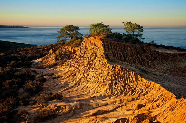
That advice also holds for the southern beach area at Torrey Pines State Beach just up the road, by the way, where California State Parks rangers turn a blind eye to nudity. The 2,000-acre Torrey Pines State Natural Reserve on the blufftops above the beach offers a sight that isn't a dime a dozen these days; one of the world's last remaining stands of the Reserve's namesake pine, Pinus torreyana, hangs on here on a bit of relatively unspoiled coastal sage scrub habitat.
Growing only here and in two groves on Santa Rosa Island in Channel Islands National Park, Torrey pines were considered one of the world's rarest pine species for a while, with fewer than 100 individuals left in the wild. Those numbers are up above 3,000 these days, but droughts and wildfire still threaten the species.
As a result, California State Parks manages Torrey Pines with a bit of a tighter hand than with many of their other parks. Trash that could spread fire is a problem, so State Parks has removed trash receptacles and requires visitors to pack out anything they bring in. Food is prohibited in the Reserve unless you're just carrying it through to the beach, where picnicking is allowed. (Water is okay, and a good idea in this windswept, dehydrating setting.) Dogs and other domestic animals are banned, even on leash.
It's well worth living with those limitations: Torrey Pines Reserve has about eight miles of stunning trails that offer hikes from quick half-mile loops to extended explorations.
San Elijo Lagoon

Seven miles up the road in Solana Beach, the San Elijo Lagoon Ecological Reserve protects 1,000 acres of tidal brackish lagoon where Escondido and La Orilla creeks meet the Pacific. The Lagoon is one of very few remaining in coastal Southern California. San Elijo is the southernmost in a series of protected lagoons reaching to San Onofre, a result of the county's coastal topography of alternating mesas and valleys running toward the sea. Interstate 5 was built right across the lagoon, and saltwater from the ocean has a harder time getting into the eastern sections of the lagoon than before the road. A restoration project set to begin in 2016 should amend that, but in the meantime the eastern part of the lagoon offers a chance to see freshwater species like cattails growing cheek-by-jowl with salt marsh species like pickleweed.
The San Elijo Lagoon Ecological Reserve, managed cooperatively by the California Department of Fish and Wildlife, San Diego County, and the and San Elijo Lagoon Conservancy, offers seven miles of trails for your wandering enjoyment. If you brought your dog to the coast only to be turned away from Torrey Pines, San Elijo may put a grin on her face: the Reserve allows dogs on a leash six feet or shorter, as long as you clean up after her religiously and pack out her waste.
Batiquitos Lagoon

Six miles north of San Elijo another California Fish and Wildlife-managed coastal wetland, the Batiquitos Lagoon Ecological Reserve in Carlsbad, has another two-miles of trails (also open to leashed dogs) from which you can watch wildlife using this 610-acre stretch of open water. The lagoon, fed by Encinitas and San Marcos creeks, has been silting up in recent decades, but a dredging project supported by the Port of Los Angeles aims to reverse that trend and restore the lagoon.
Wildlife using Batiquitos Lagoon includes the usual assortment of engaging shorebirds and waterfowl, including endangered clapper rails and snowy plovers.
Agua Hedionda

Five more miles north in the next valley meeting the sea, the California DFW's Agua Hedionda Lagoon Ecological Reserve protects 186 acres of land, including salt marsh and riparian willow forest at the head of its namesake lagoon. The 400-acre lagoon itself has been used in one way or another for decades by human industry, including aquaculture. In fact, the large gas- and oil-fired power plant on the south shore significantly remade the lagoon itself. Once a stagnant pool at low tide, Agua Hedionda Lagoon, whose name means "stinking water" in Spanish, was opened up to the ocean even at low tide so that the Encina Power Plant could use the lagoon for cooling water.
Human changes to Agua Hedionda aren't over: the lagoon is the site of a new desalination plant. But you can still hike a few short trails in the area, including the mile-long Kelly School Trail in the Department of Fish and Wildlife's Reserve at the other end of the lagoon from all that industrial hubbub.
Buena Vista Lagoon

Just a little ways north of Agua Hedionda lies the freshwater Buena Vista Lagoon along the city limits of Carlsbad and Oceanside. Buena Vista is protected by the California Department of Fish and Wildlife Buena Vista Lagoon Ecological Reserve -- the northernmost of DFW's lagoon reserves along the San Diego coast. The 206-acre reserve, established in 1968, is DFW's oldest Ecological Reserve, and it's also got a long tenure as a bird sanctuary: firearm discharge into the marsh was banned in 1939.
Along with those birds -- hundreds of species of which have been documented using Buena Vista Lagoon -- the Reserve is also home to the beleaguered western pond turtle and western spadefoot toad. So keep a close eye on any green animals you may spot.
Trestles Natural Wetlands, San Onofre

One of Southern California's wildest coastal watersheds can be glimpsed at the Trestles Natural Wetlands Preserve at San Onofre State Beach. San Mateo Creek may well be unique among coastal creeks in Southern California in that it has escaped almost all of the channelizing, watershed development, and ecological degradation that has afflicted other SoCal streams. Though the creek does dry up on the surface during the summer, its underground flow -- from a federal wilderness area through ranchland and the Camp Pendleton Marine Corps Base -- feeds the remarkable wetlands in the 160-acre preserve.
Trail access to the Preserve and the wetlands is a little limited, though a dirt road does provide hiking access along the wetlands' northwest shore between San Onofre State Beach and the park's San Mateo Campground. You can also explore the margins of the San Mateo creek watershed a little ways upstream of the preserve by following the trails that leave the campground and head north and uphill.


