Is L.A. a West Coast City? For Many, It's the East. Or the North.

Union Bank is a proud sponsor of Lost LA. 
Mayor Eric Garcetti has often described Los Angeles as “the western capital of America, the northern capital of Latin America, and the eastern capital of the Pacific Rim.” It’s the perfect kind of statement by a native-born mayor, describing, through superlatives and with a tinge of boosterism, the proverbial crossroads formed by the migrant and immigrant communities that form his hometown metropolis.
While our seemingly occidental position might be true on a map of the Lower 48, the compass points to other directions with respect to the location of our big dot on a globe.
But the statement also perfectly sums up our geographical identity: the rest of America views Southern California – sometimes pejoratively – as The West, Out West, the Wild West, or the Left Coast (though troubadours from Roy Rogers to Brian Wilson to Snoop Dogg have made it quite clear that living in this part of the world is nothing to be ashamed of.) And while our seemingly occidental position might be true on a map of the Lower 48, the compass points to other directions with respect to the location of our big dot on a globe.
Anyone with a basic knowledge of U.S. history knows that our country originated as colonies along the Atlantic coast, across the pond from Mother England. After our rebellious emancipation, the juvenile nation expanded westward, albeit at the expense of the indigenous peoples that have already lived here. The West became a metaphor for The Great Unknown, the vast open expanse equally synonymous with breathtaking natural wonders, deadly dangers, and a chance to start anew. “Go West, young man!” was the rallying cry of expansionism.
Similarly, Mexico’s perspective of The Great Unknown had the compass point northward, from Distrito Federal, past the Sierra Madre mountains. The place beyond was El Norte. Mexicans from the northern states listen to Norteño music – their equivalent of Country & Western music some of which is played by groups like Los Tigres Del Norte. And what we call Americans, our neighbors to the south call Norteamericanos.

The obsession with this geodirectionalism has its roots in Eurocentrism. Europe, being the western end of what was then the known world, called dibs on The Western World. To the east, past the shores of the Mediterranean was the Middle East, and even beyond that was the Far East, populated by people they described as “Oriental.” But when a “New World” was realized even further west, was this new continent called the Far West? Not really, because the great kingdoms of Europe soon laid claim to various parts of the “New World” and eventually they were co-opted as part of the Western World by means of empire. Geodirectionalism lives on today in the United States, where we divide this country by East coast and West coast, North and South, and where its three largest cities are popularly divided by Uptown vs. Downtown, Eastside vs. Westside, and Northside vs. Southside. Old habits die hard.
California, or America as a whole, is neither “east” nor “west.” It is simply “there” – or even “here.”
People from Asia who immigrate to the United States – who must travel east to go west – do not typically view their journey in geodirectional terms. The Chinese diaspora, which inhabits every continent, is too widespread to be concerned with where the compass needle is pointing. For Asians in America, crossing the vast Pacific, whether by boat or airplane, is simply navigating a large body of water, defined by sheer distance, and complicated by climate and time zones. And the over-romanticized concept of the American Dream is not always valid or uniform. Asians cross the Pacific for myriad reasons: tourism, family, trade, temporary employment, utter survival. For the Chinese workers who built the railroads in the 1800s, for my Philippine-born parents who arrived here as young professionals in the ‘60s, and for the Southeast Asian refugees escaping their war-torn homelands in the ‘70s, America was not so much a dream but rather an unexpected opportunity. Some originally planned to return home after a few years, but the economic and logistical realities of American life soon changed their plans. California, or America as a whole, is neither “east” nor “west.” It is simply “there” – or even “here.”
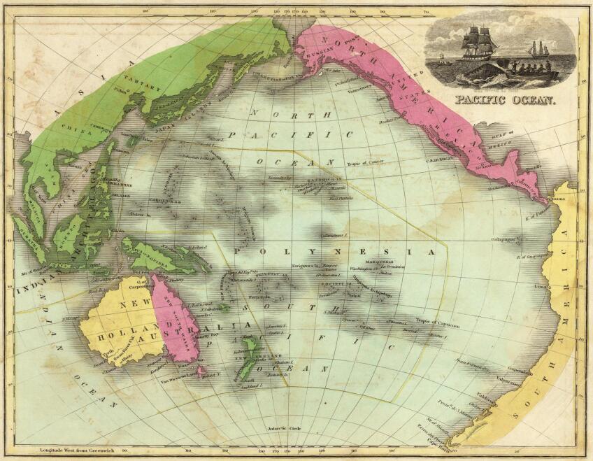
Maps of the world usually incorporate the perspective of the country they’re intended for; maps made for U.S. classrooms would usually have the North American landmass front and center, for example. But how’s this for a new cartographic perspective? Since the planet Earth’s surface is 70 percent water, let’s put the largest and most voluminous body of water in the center, which would be the Pacific Ocean. To the far east end of the map, beyond the Americas, is the Atlantic Ocean. Europe is at the far west, just where it has always thought itself to be. East Asia is at the western edge of the Pacific Rim, while the dot that represents Los Angeles sits proudly at the eastern edge, north of Latin America, and still in the southwest corner of the United States.
Now everybody will know exactly where we are.
This article was originally published on Nov. 11, 2016. It has been republished in conjunction with the broadcast of Lost LA's "Pacific Rim" epsiode.


