
The Convoluted Logic of L.A.'s Numbered Avenues

 A map of Los Angeles City, 1867.
In Los Angeles, an 1867 map shows the streets and avenues that make up the city. | The Huntington Library, San Marino, California
As Los Angeles expanded, a need to clear up confusion for citizens came when duplicate numbered streets and avenues appeared throughout the city.
Support Provided By

The following post is republished in partnership with USC Libraries.


There's an obvious logic to Manhattan's numbered street grid. Name any intersection of a numbered avenue and street — 57th and Fifth, for instance — and you immediately know its location on the island, and its distance from any other numbered crossroads.

Los Angeles also offers the urban navigator a set each of sequentially numbered streets (1st through 266th) and avenues (16 through 67, always expressed in cardinal, not ordinal terms), and yet their logic is not as evident as Manhattan's. Streets never intersect with avenues — though avenues sometimes intersect with each other, or dead-end in a hillside only to reappear a half-mile away — and avenues 1 through 15 are mysteriously absent. (To add to the confusion, numbered grids in places like Venice, San Pedro and Leimert Park survive as remnants of older subdivisions, originally plotted outside L.A.'s municipal boundaries and only later annexed to the city.)

The architects of this chaos intended something more methodical. When it convened in 1896, a special city commission sought to impose order on a sprawling grid of Northeast Los Angeles streets whose names often duplicated and sometimes triplicated each other. City maps had featured consecutively numbered streets since 1849, and the sequence had recently been extended to the southern city limit. Now the commission proposed a mirror sequence of "ways" (soon corrected to "avenues") north of the old Spanish plaza, overwriting old street names.

The left side of the page from the 1921 Baist's real estate atlas of Los Angeles.
1/2 In the city of Los Angeles, a street overhaul took place to clear up confusion due to duplicate street names. | Huntington Library, San Marino, California
The right side of the page from the 1921 Baist's real estate atlas of Los Angeles.
2/2 The expansion of Los Angeles created disorder once again as numbered streets stopped running parallel and began to intersect. | Huntington Library, San Marino, California

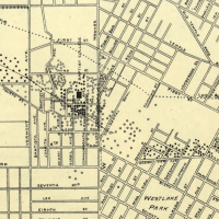
After contentious debate, the city council adopted the proposal on February 23, 1897. For a time, wayfaring through Los Angeles was improved. The duplicated names that once disoriented residents and tourists alike were eliminated; one of the city's three Walnut Streets became Avenue 20, and a second Avenue 52. And although the streets and avenues never intersected to create coordinates, they did helpfully count the blocks along the city's then-dominant north-south, Pasadena-San Pedro axis. Still, there were limitations. For one, property owners on the west bank of the Los Angeles River preferred the old names, so the avenues began on the east side, with 16. More consequentially, as urban development later spilled over Mount Washington and into the ravines of Highland Park, the grid folded onto itself so that numbered avenues, meant to run parallel, instead intersected, thus confusing the logic of a once-orderly scheme.

Support Provided By
Read More
A sepia-tone historic photo of a man holding a cane standing in front of a food stand, surrounded by various crates, boxes, and advertising signs promoting cigarettes, candies, barbeque and more.

Pasadena Claims To Be The Home Of The Cheeseburger — But There's Beef

The cheeseburger was supposedly invented by Lionel Sternberger at The Rite Spot in Pasadena, when he added a slice of cheese to a regular beef burger and called it the "Aristocratic Hamburger." But the real history behind this fast food staple is a bit more complicated.
A hand-colored postcard of a large, white, colonial-style building with a green tiled roof stands behind a lush landscape of flower beds, a green lawn and many varieties of trees, with mountains looming just behind. An American flag waves at the top of a flagpole above the roof.

From Hiking to Hospitals: L.A. at the Center of the Pursuit of Health

The opportunity to get and stay healthy was a major draw for people to both visit and move to Los Angeles — whether it was during the tuberculosis epidemic (a.k.a. the "forgotten plague") during the 19th century or the health and wellness boom of the early 20th century. Both of these topics are explored in Season 6 of the PBS SoCal Original Series Lost LA.
A black and white photo of an adult dressed as the easter bunny with a giant costumed head, holding a little girl on their left who gives it a kiss on the cheek and, with his right arm, holding a little boy who brings his hands to his eyes as though wiping away tears.

Behold the Bunnies and Bonnets of L.A.'s Past Easter Celebrations

The onset of the spring season heralds the arrival of fragrant flowers in bloom — and all the critters that enjoy them, including the Easter bunny and families who anticipate his arrival with egg hunts, parades and questionable fashion choices.