
When Model T’s Scaled Santa Monica’s California Incline

California Incline (cropped for header)
LMU Library
Support Provided By

Functionally, it was little more than a highway ramp – a 1,400-foot-long, 3-lane roadway that climbed 84 feet between Pacific Coast Highway (PCH) and Santa Monica’s Ocean Avenue. But that description hardly hints at the charm of the original California Incline. Driving down, the palms of Palisades Park receded into the sky as one abruptly left behind the urban grid of Santa Monica and entered the surf and sand (and traffic) that is the realm of PCH.

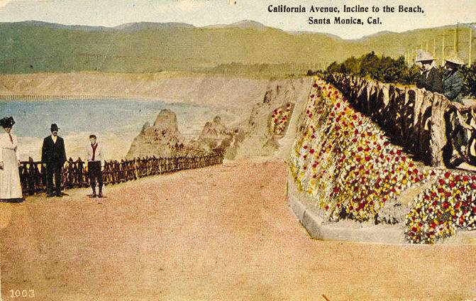
Footpaths like the Sunset Trail and stairways like the 99 Steps preceded it, but the California Incline was the first automobile shortcut over Santa Monica’s ocean bluffs. When it opened around 1905, Linda Vista Drive (as it was then called) was a dirt path carved into the cliffside. Only later was it paved and named for its intersection with California Avenue. In 1935, construction of PCH along the base of the bluffs further reconfigured the California Incline, widening the roadway adding a concrete balustrade that remains its most notable architectural detail.

Erosion brought more change in the ensuing decades. In places where the sandstone beneath the ramp crumbled away, 14 concrete columns took its place, keeping the roadway’s 8-inch slab from falling onto PCH below. That engineering solution looked picturesque from below, but Caltrans and the city of Santa Monica deemed it unsafe. In 2014, the city began demolishing the old incline. In its place rose a new ramp, built to modern seismic standards and with more generous provisions for pedestrians and cyclists. It opened Sept. 1, 2016.

Early automobiles, including a Ford Model T, descend Santa Monica's California Incline in the early 20th century.
Early automobiles, including a Ford Model T, descend Santa Monica's California Incline in the early decades of the 20th century. Image courtesy of the Randy Young Collection, Santa Monica Library Image Archives. 
The newly reconstructed California Incline features generous space for pedestrians, who have used the ramp since its early days.
The newly reconstructed California Incline features generous space for pedestrians, who have used the ramp since its early days. Image courtesy of the Randy Young Collection, Santa Monica Library Image Archives. 
Postcard of California Incline, circa 1913-20
Postcard of California Incline, circa 1913-20. Image courtesy of the Werner von Boltenstern Postcard Collection, Department of Archives and Special Collections, William H. Hannon Library, Loyola Marymount University.
This 1928 photo of the California Incline shows the sandstone bluffs that eventually crumbled away beneath the roadway.
This 1928 photo of the California Incline shows the sandstone bluffs that eventually crumbled away beneath the roadway. Image courtesy of the Pacific Palisades Historical Society Collection, Santa Monica Public Library.
A mid-1930s modernization project on the incline accompanied the widening project along the Roosevelt Highway (PCH).
The mid-1930s construction of the Roosevelt Highway (PCH) added modernizations to the California Incline, including measures to shore up the ramp in the face of the palisades' erosion. Photograph (dated 1934) courtesy of the Adelbert Bartlett Papers. Department of Special Collections, Charles E. Young Research Library, UCLA.
A concrete balustrade, added as part of a reconstruction project in 1935 and seen here in a circa 1940s postcard, became the incline's defining feature.
A concrete balustrade, added as part of a reconstruction project in 1935 and seen here in a circa 1940s postcard, became the incline's defining architectural feature. Image courtesy of the Santa Monica Public Library Image Archives.
The California Incline in the 1960s, when a large sign welcomed motorists leaving PCH to Santa Monica.
The California Incline in the 1960s, when a large sign welcomed motorists leaving PCH to Santa Monica., by nmasters

Editor’s note: This article originally appeared on Los Angeles Magazine’s City Think blog on April 22, 2014. It has been updated here and expanded with additional images.

Support Provided By
Read More
A sepia-tone historic photo of a man holding a cane standing in front of a food stand, surrounded by various crates, boxes, and advertising signs promoting cigarettes, candies, barbeque and more.

Pasadena Claims To Be The Home Of The Cheeseburger — But There's Beef

The cheeseburger was supposedly invented by Lionel Sternberger at The Rite Spot in Pasadena, when he added a slice of cheese to a regular beef burger and called it the "Aristocratic Hamburger." But the real history behind this fast food staple is a bit more complicated.
A hand-colored postcard of a large, white, colonial-style building with a green tiled roof stands behind a lush landscape of flower beds, a green lawn and many varieties of trees, with mountains looming just behind. An American flag waves at the top of a flagpole above the roof.

From Hiking to Hospitals: L.A. at the Center of the Pursuit of Health

The opportunity to get and stay healthy was a major draw for people to both visit and move to Los Angeles — whether it was during the tuberculosis epidemic (a.k.a. the "forgotten plague") during the 19th century or the health and wellness boom of the early 20th century. Both of these topics are explored in Season 6 of the PBS SoCal Original Series Lost LA.
A black and white photo of an adult dressed as the easter bunny with a giant costumed head, holding a little girl on their left who gives it a kiss on the cheek and, with his right arm, holding a little boy who brings his hands to his eyes as though wiping away tears.

Behold the Bunnies and Bonnets of L.A.'s Past Easter Celebrations

The onset of the spring season heralds the arrival of fragrant flowers in bloom — and all the critters that enjoy them, including the Easter bunny and families who anticipate his arrival with egg hunts, parades and questionable fashion choices.