6 Hikes to Help You Up Your Pacific Crest Trail Game

Imagine finishing up your day hike and seeing one or two backpackers the trailhead. They look as if they've been on the trail for weeks and are hitchhiking for a ride into town to resupply.
For long distance hikers, or thru-hikers, hitchhiking is a small part of the reality of completing the Pacific Crest Trail (PCT). The PCT is 2,650 miles of scenic trail from the U.S.-Canada border through Washington, Oregon and California to the U.S.-Mexico border. Northbound thru-hikers begin their trek in Campo, California around March and April. Throughout the spring and summer, these backpackers can be seen traversing the trail throughout Southern California.
You don't have to be a thru-hiker to enjoy the scenery of the Pacific Crest Trail. Spanning over 200 miles along the northern edge the San Bernardino and Angeles National Forests, the Pacific Crest Trail has a number of day hikes for every level of recreation.
1. Crystal Mountain
Crystal Mountain features a large crystal quartz dome named The Eye of God, or Hatauva as called by the Serrano people. It is considered a sacred tribal landmark and the Serrano people refer to it as the eye of their creator, Kruktat.
The large quartz feature is near the turnaround point of the trail. As you get closer, you will see quartz deposits up to 100 feet from the Eye of God and notice its glinting sheen amongst the brown and green backdrop of pine trees.

The views along this hike overlook Baldwin Lake and a unique transitional area of the forested mountains and the Mojave Desert. On this just-under-four-mile out-and-back trail, hikers walk alongside an interesting landscape of neighboring Joshua Trees, cacti and evergreen conifer trees.
This hike is an easy, with little elevation changes but depending on the weather and what time of day you do this hike, it is very sun exposed and can get quite hot, so make sure to prepare accordingly.

Parking for Crystal Mountain trailhead is located on large turnoffs off of Highway 18 on the border of Big Bear and Lucerne Valley, about eight miles from the town of Big Bear Lake.
2. Bertha Peak
At 8,200' of elevation, Bertha Peak provides an aerial view of Big Bear Lake, the Big Bear Solar Observatory, Mount San Gorgonio and Mount San Antonio to the west. Around 12 miles west along the PCT from Crystal Mountain, and just a 15-minute drive away along North Shore Drive, the PCT intersects the Bertha Peak Trail.
Further into the San Bernadino National Forest, hikers can expect towering Jeffery pines and their vanilla scent throughout this trail. The incline is steady until a final, steep tenth of a mile to the summit. If you do this moderate, eight-mile round trip hike in the afternoon, you can enjoy sunset over the lake from various scenic benches along the trail.

Parking is available at the Cougar Crest Trailhead with use of a National Parks Pass or Adventure Pass. Additional parking is available at the Big Bear Discovery Center, which connects to the Cougar Crest Trailhead lot via mile long paved trail.

3. Mount Baden-Powell
Mount Baden-Powell, named after a founder of the Boy Scout and Girl Scouts, is one of the more popular day hikes of the PCT. With a peak at 9,407', and 40 switchbacks to get there, Mount Baden-Powell boasts 360-degree views of the Los Angeles Basin, Inland Empire and expansive ridges of the San Bernardino and Angeles National Forests.
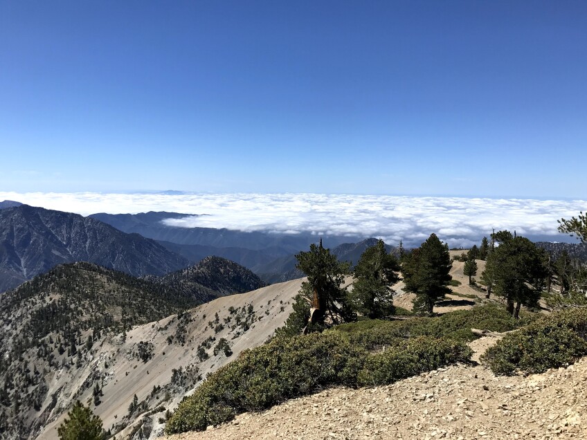
1,000' of elevation gain for every mile to the summit keeps this hike challenging, but the trail is well-maintained, easy to follow and worth the panoramic views, all within a round trip just above eight miles.
Hikers can enjoy zigzagging through Jeffery, Ponderosa and Lodgehole pines that frame the desert views to the north. Once at the saddle before the summit, hikers can see the Wally Waldron Tree, a 1,500-year-old weather worn Limber pine that is believed to be the oldest known living thing in the San Gabriel Mountains.

The drive to the trailhead goes along the eastern end of Highway 2, passing by the town of Wrightwood and Mountain High Resort. Vincent Gulch Divide serves as the trail head, and is an access point to other trails in the area. Ample parking is available, but fills up quickly, and requires National Parks Pass or Adventure Pass.

4. Save for Later: Deep Creek Hot Springs
Deep Creek Hot Springs is a natural thermal spring located along the Deep Creek fork of the Mojave River on land managed by the Bureau of Land Management (BLM). Surrounded by large granite boulders and lined with willow, alder and cottonwood trees, the site provides both hot and cold-water pools.
Bring a swimsuit to take a dip in the hot springs, or enjoy them in your birthday suit. At the hot springs, nudity is permitted! Prepare for potential naked hiker sightings while relaxing at the hot springs.

There are three routes to access Deep Creek Hot Springs. The route using the PCT is six miles each way throughout the northern foothills of the San Bernardino National Forest. The Bradford Ridge Path is almost three miles each way along slippery and rocky terrain, accessible from California State Route 173. The most popular and shortest access point is via Bowen Ranch for a $5 per person fee. This hike is two miles each way with a 950' elevation change from the beginning of the trailhead to the hot springs.

Each route is entirely exposed with no shade so it's a great hike to save for cooler seasons. Regardless, be sure to pack in enough water for this hike. No amenities, restrooms or water, are provided at the trail sites.
The hot springs hosts a great diversity of wildlife of any drainage in the San Bernardino National Forest. Although the hot springs is on public land managed by the BLM, Bowen Ranch is private. To protect the area for conservation and future use, please abide by the rules that Bowen Ranch has put forth and practice leaving no trace.
5. Pacifico Mountain Loop
Pacifico Mountain is a challenging twelve-mile loop on the western edge of the San Gabriel Mountains. Since the trailhead is further north along CA Hwy 2 and Angeles Forest Highway (County Road N3), passing more popular Angeles National Forest hikes like Strawberry Peak or Switzer falls, the Pacifico Mountain loop is less traveled.

With a National Parks Pass or Adventure Pass, park at the Mill Creek Summit Picnic Area and Pony Park Day Use Area, where you can enjoy a pre or post-hike snack at picnic tables.
During PCT thru-hiking season, from mid-March through September, more backpackers than day hikes can be seen along this trail. The northern edge of this loop is on the PCT for around seven miles. Hikers can expect a steady incline to sweeping views of the high desert to the north and a mix of chaparral flora, then evergreens as the trail makes a final incline before reaching Mt. Pacifico Campground at the 7,100' summit.
The campground is available first come first serve and is accessible via a dirt road which serves as the southern end of the loop back to the parking areas. Along the car accessible dirt road, hikers can expect an easily graded decline and gaze south to views of Mount Wilson and the San Gabriel Mountains.
6. Vasquez Rocks
A popular and family-friendly location with trails ranging from one to four miles, the Vasquez Rocks Natural Area Park in Agua Dulce marks the PCT's descent from the San Gabriel Mountains.


Even if you're not a hiker, you might recognize the park's iconic sandstone rock feature. It juts out at a 45-degree angle and has been the backdrop for dozens of film and TV productions, including Star Trek, The Flintstones, and The Muppet Movie. Vasquez Rocks has also been featured in music videos by Radiohead, Michael Jackson, and BTS.
Throughout the trail, hikers walk amongst high desert plant communities of pinyon-juniper woodland, coastal sage scrub and chapparal. Geologists estimate that the oldest parts of the Vasquez Rocks are around 25 million years old.
Hikers can visit the Interpretive Center on site to learn more about the Tataviam Native Americans from the Vasquez Rocks area. Visitors can also learn more about the rich film history of the site in the Interpretive Center as well as freshen up with access to full restrooms, water and a small gift shop.


