7 Ways to Explore Dana Point's Rich History and Marine Life

In the 19th century — before the first gold strike that led to an influx of would-be prospectors — there wasn't much reason for East Coasters to come out West, which was considered wild, savage and inhospitable.
To those from more "civilized" regions, it might've felt downright prehistoric.
But in 1835, the namesake of the city of Dana Point — then-Harvard student Richard Henry Dana, Jr. — was the exception that became the rule when he set sail on a brig-type tall ship called the "Pilgrim."
Since this was 80 years before the Panama Canal opened, the "Pilgrim" rounded the tip of South America and landed at San Juan Cove — today's Dana Point Harbor, the only safe anchorage between Santa Barbara and San Diego at the time.
Dana deemed the area "romantic" and remarked at its grandeur, publishing a memoir of his sea voyage and time spent at San Juan Cove in 1840 as "Two Years Before the Mast."
The book was a hit — and people arrived in droves to see Dana Point (as it's been officially known since 1989) with their own eyes.
It's far less rugged and far more refined now, but the rich history is there — if you know where to look.
Here are the seven best ways to get to know the historic, literary and watery sides of Orange County's premier surfing and sailing destination — with plenty of breathtaking ocean views, to boot.
1. Del Prado-Lantern District
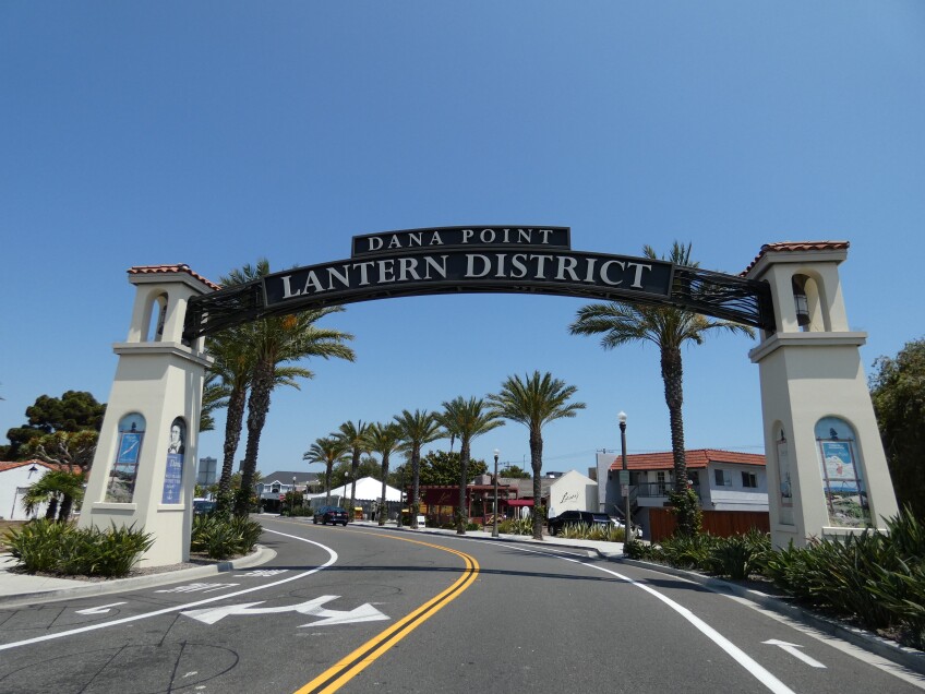
The area known as The Lantern District is where entrepreneurial types once advertised wares for trade to the ships that came rolling in — by lighting up color-coded lanterns. The most famous of those were the sailors who chucked cowhides (which had been tanned at Mission San Juan Capistrano) off the cliffs, to be retrieved by the Yankee merchant seamen standing below — a.k.a. "hide-droghing."
The lantern motif persists today, through the street names and even lawn ornamentation of the homes in the Lantern District — though the trade does not. You can enter the Lantern District through the arch on Del Prado Avenue, where it splits off from the Pacific Coast Highway.


Just beyond the gateway arch, at 34105 Pacific Coast Highway, you'll find the oldest building in Dana Point — currently vacant, but built as the real estate office for the development efforts of Sidney Woodruff (of Hollywood Sign fame). The Spanish Colonial Revival-style structure features a red terra cotta tile roof and tiled doorways and fountains — under restoration since 2020.
Next, head south to where the Street of the Blue Lantern dead-ends, and you'll find the blufftop pavilion built in the mid-1920s to showcase ocean views for that same planned development. Today, the "Blue Lantern Gazebo" is located at Ken Sampson Overlook Park — named after the former Director of the Orange County Harbors, Beaches and Parks District whose administration spearheaded the construction of Dana Point Harbor. Unfortunately the gazebo has been fenced-off since 2018 — but although you can't enter it, you can get a good look at it.


At the southern terminus of Old Golden Lantern, you'll find another overlook at Compass Point, just above Heritage Park — this one dedicated to Doris Walker, a local historian and founder of the Dana Point Historical Society. Look for a bronze sculpture representing the many features of the area by artist Christopher Pecharka. For more historic sites throughout the Lantern District, see the Dana Point Historical Society's virtual historic walking map.
2. Bluff Top Trail, Lantern District

Although it's technically part of the Lantern District, the Bluff Top Trail — located between Street of the Amber Lantern and Street of the Violet Lantern — is worth its own entry.
This short, historical walk is "ground zero" for where Hollywoodland developer Sidney Woodruff envisioned capturing the romance and adventure of "Two Years Before the Mast" to attract tourists and homebuyers alike to his burgeoning resort community. Real estate developments were booming in the environs north of San Juan Cove in the 1920s — and Woodruff, along with oil heir Edward "Ned" L. Doheny Jr., tried to make a go of it with the ill-fated Dana Point Inn, breaking ground in 1930, the year after the cataclysmic stock market crash of 1929.
Construction on the Inn halted on 1931, leaving it half-finished — and its ruins stood atop the bluff for decades. All that's left now is a bit of the old rock-lined walkways and a set of stone arches that mark the former hotel site like a tombstone.

Walk 0.2 miles (one way) to pass through the arches and read the historical plaque for the Dana Point Inn. There's also a life-size bronze statue of a "hide-drogher" tossing his cowhide down to the ships below — sculpted by F. Benedict Coleman and installed on the walkway in 1990.
3. Doheny House #1, Capistrano Beach

Ned Doheny's contribution to Dana Point should not be underestimated — because it doesn't just end with his family's contribution of 41 acres to create Doheny State Beach in his memory. Today, his legacy can also be found throughout Capistrano Beach, officially part of Dana Point since 1989.
In 1926, Doheny had established The Capistrano Beach Company along with his wife Lucy's brothers, Clark and Warren Smith. The company purchased what had previously been known as San Juan-by-the-Sea — a subdivision established in 1887 by the Pacific Land Improvement Company, a subsidiary of the Santa Fe Railroad Company.
In the three years before his untimely death in 1929, Doheny built dozens of red tile roofed, Spanish Colonial Revival-style "Doheny Houses" along the palisades above the beach. A total of 21 of them survive today, including the first home of the development — Doheny House #1 at 35101 Camino Capistrano (near the intersection of Camino de Estrella, named for Estelle Doheny, Ned's mother).
While Ned was alive, Doheny House #1 (a.k.a. Palisades House #1) served as a gathering place for Doheny family members and their guests. After his tragic death, oil baron Edward L. Doheny Sr. (Ned's father) and his Petroleum Securities Company took over the Capistrano Beach development and the house became the home of Doheny development supervisor Harrison "Harry" Leyden (and subsequently, his son Don and daughter-in-law, local artist Louise Leyden). Its history earned it a spot on the Dana Point historic register in 2001 and made it eligible for the National Register. However, the threat of demolition has loomed over the past several years.
Although Doheny House #1 is not open to the public, you can see its façade from the sidewalk and street — including the historic lamppost out front, which matches those found elsewhere in Capistrano Beach, dating back to its original development. To get a sense of the spectacular ocean vistas visible from its backyard, go next door to the Chloe Luke Overlook, open 6 a.m. to 10 p.m. daily.


4. Pines Park, Capistrano Beach

Today's Pines Park at Camino Capistrano and Doheny Place overlooks the parking lot where Ned Doheny's members-only Capistrano Beach Club once stood as the focal point of his Capistrano Beach development. And while the first thing you might notice at Pines Park is the anachronistic grove of pine trees by the beach, there are intriguing traces of history you can find if you take a closer look.
Originally a private park for residents of the Capistrano Beach palisades — formerly known as "Pines Bluff Park" or "Doheny Pines Park" — it once featured a gazebo, rose garden, wooden walking path and staircase down to the beach (today, Capistrano Beach Park). All of those were located in the lower "bowl" area of the park — known then as "Bowl Gardens" — and unfortunately were razed in the 1960s after decades of neglect (and wood rot). What you can still see today includes the natural "bowl" formation in the bluff (now essentially a dirt patch), an overlook made of stone, old retaining walls, and a rock-lined trail.

Pines Park is now open for any and all visitors 6 a.m. to 10 p.m. daily. Enjoy the shade under the pines, the grassy expanse, and public art pieces including "Epiphany" by Ashley Keene (part of the 2013 Elephant Parade) and "Summer Fun," a bronze sculpture by artist Randolph Rose, installed in 2016. There's also a locally famous "climbing tree" and killer sunset views. Seasonal celebrations include a Memorial Day ceremony and holiday tree lighting hosted by the City of Dana Point.
5. Watermen's Plaza


Established in 2018, Watermen's Plaza pays tribute to Dana Point's sailing and surfing heritage through interpretive displays, statuary and other art. Its most striking feature is a bronze statue designed by local artist Lance Jost and sculpted by local artist Bill Limebrook, called "Hobie Riding the Wave of Success" — a memorial to Hobie Alter, "The Surfboard King" who opened SoCal's first surf shop in Dana Point at 34195 Pacific Coast Highway (now part of the Cali Costa cantina next door). Alter also created a small catamaran you could sail (or race) with a two-person crew — the world-renowned Hobie Cat.
Another "waterman" honored at the Plaza is surfer Phil Edwards — a member of the Hobie surfing team and the first surfer to ever be featured on the cover of Sports Illustrated. He's also widely considered the first professional surfer — and he kept close ties to Dana Point (and its legendary surf break, "Killer Dana") even after earning national recognition. The statue, called "Surfing Great," is also the work of Limebrook — who's not only an artist but also a surfer.
Limebrook's third contribution to Watermen's Plaza is a life-sized bronze depiction of Bruce Brown, one of the first filmmakers of surfing. Also an avid surfer himself, Brown is probably most famous as the documentarian behind the seminal film "The Endless Summer" — which he narrated, directed, produced, shot around the world and edited in Dana Point at his production office (24633 Del Prado Avenue, now the Bonjour Café & Bistro). "The Endless Summer" gets its own honorary place at Watermen's Plaza, too, with a mosaic of the film poster by artist Mia Tavonatti. Its designer, John Van Hamersveld, based it on a photo taken right in Dana Point, at Salt Creek Beach.

Watermen's Plaza is located near the pedestrian bridge that crosses the PCH just past Del Obispo Street (which becomes Dana Point Harbor Drive). Unfortunately, there's nowhere to park your car without walking some distance — but it's easily accessible both on foot and by trolley, which is free and stops right in front of the park. As a bonus, walk less than 0.2 miles down the sidewalk towards San Juan Creek to take a gander at the PCH monument, which marks where "The Most Beautiful Drive in America" begins.

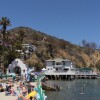
6. Whale & Dolphin Watching, Dana Point Harbor


Earlier this year, Dana Point was named the first Whale Heritage Site in the U.S. And at Dana Point Harbor, you've got several opportunities to get out on the water to try to see humpbacks, fin whales, gray whales and more. TheOcean Institute offers occasional educational cruises (including during the annual Festival of Whales), while wildlife cruises with Dana Wharf Whale Watching and Capt. Dave's Dolphin & Whale Watching Safari run several times daily.
Right now is technically blue whale (Balaenoptera musculus) season in Southern California, but it's still incredibly rare to see them — despite being the largest animals on the planet, weighing over 300,000 pounds (150 tons) and measuring over 100 feet in length. If you do spot one, it might delight you with a spout through its blowhole and a flick of its tailfin before diving down for krill (its meal of choice) and leaving behind a glassy footprint on the water's surface.
Besides whales, this part of the Pacific Ocean also contains more dolphins per square mile than anywhere in the world. The months of July and August constitute the main calving season for the common dolphin (Delphinus delphis) — so, this time of year, you might see little baby dolphins swimming alongside their mothers.


At the bow of Capt. Dave's high-speed, 50-foot catamaran called "Manute'a," there's a net that you can lie on top of and reach down to boop the snoots of dolphins as they swim right under the boat. The "Manute'a" also features two underwater viewing pods that let you see eye-to-eye with all creatures great and small in the surrounding water.
Contact each individual company for schedules, pricing, availability and current COVID-19 protocols (which can change quickly and without notice). Daytime parking at Dana Point Harbor is free but limited, so arrive early to nab your spot. Onsite dining and shopping options are available as well.
7. Ocean Institute, Dana Point Harbor


For nearly 40 years, the Ocean Institute had been home to a circa 1945 replica of the "Pilgrim," the brig that brought Richard Henry Dana, Jr. into San Juan Cove — until March 2020, when it sank and its remains were later demolished.
The non-profit organization's other tall ship is the "Spirit of Dana Point" — a replica of a Revolutionary War-era privateer schooner, which is currently dry-docked in San Diego for a massive restoration effort. For more tall ships, you can attend the Ocean Institute's annual Maritime Festival (formerly the Tall Ships Festival).
It's all located near a jetty made out of Catalina Island granite — which calms the waters enough for kayaking on a guided tour, during which you'll see sea birds (cormorants, Western gulls, pelicans), crabs, and sea lions, and learn about the history and development of Dana Point. Behind the Ocean Institute is a Marine Conservation Area, where OI naturalists can take you on a guided tidepool hike to discover the critters that live in those shallow waters (which are best explored in winter). A number of other field trips for school-aged children are also available.
All visitors over the age of 2 must wear face masks inside OI's facilities. Participants of outdoor excursions may also be asked to wear a face covering. Hand sanitizer and hand-washing stations will be available. For the most updated COVID-19 protocols, call OI directly at (949) 496-2274.