Seven Neighborhood Gems Along the L.A. River


We’re getting better when it comes to the L.A. River. Ten years ago, most of us didn’t even know that L.A. even had a river.
And like many other aspects of Los Angeles, the river that runs through it can be confusing, hidden and downright intimidating.
The fact is that the L.A. River grew into the city of Los Angeles — starting near Downtown L.A., where the Tongva people lived and the Spanish conquistadores on the Portolá expedition camped.
And as L.A. expanded, it did so along its river.
It’s hit a few bumps along the way (including the 1936 Flood Control Act that channelized it with concrete walls) — but now, you not only can get to the re-wilded parts of the Los Angeles River, but you can get onto them, too (for a part of the year)!
Fortunately, you don’t have to tackle all 51 miles of it all at once.
Here are seven of the best — but overlooked — places along the L.A. River to get acquainted with and accustomed to our city’s life-giving waterway.
You could hit them all in one day — but go ahead and discover them at your own pace. Just give them enough time to surprise and delight you.
1. Sepulveda Basin Recreation Area, Encino


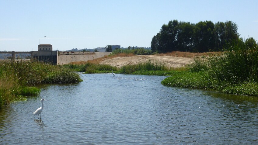


Upstream from the Sepulveda Dam, just north of the juncture of the 405 and the 101, the L.A. River is a thriving, watery surprise with multiple creeks flowing into it and a soft river bottom that you can squish your toes into. Located a stone’s throw from the Sepulveda Basin Wildlife Reserve, it should come as no surprise that it became one of the first two areas that the U.S. Army Corps of Engineers and the California Department of Fish and Game opened for public recreation in 2015.
You’ll find an entrance/exit ramp on the south bank of the river, just downstream from the Burbank Boulevard overpass. That’s where L.A. River Expeditions launches kayaks for its two-hour, guided eco-tours along two miles of the recreation zone. Beginners are welcome and all equipment (kayaks, paddles, helmets, etc.) is included in your booking. If you’ve got your own kayak — or prefer to rent one from L.A. River Kayaks — you can head into the water on your own, no permit or fee required. Organized groups like schools, non-profits and for-profit businesses need to secure permits (for a fee) and show proof of insurance. Everyone’s got to wear a life jacket while on the water, and no motorized boats are allowed.
You’re also welcome to try to catch some largemouth bass, tilapia, green sunfish, and mosquito fish in this area (from the banks or a boat on the water) — as long as you’ve got a fishing license from the California Department of Fish and Wildlife. Regardless of how you choose to enjoy the L.A. River, you’re entering at your own risk. Remember why it was filled with concrete and channelized in the first place: It has a tendency to flood! And you don’t want to be anywhere near its banks when there’s a flood or thunderstorm watch or warning. Even if the skies are clear, make sure it’s been 72 hours since the last rain to ensure safe water quality.
2. North Valleyheart Riverwalk/Valleyheart Greenway, Studio City


Starting near the intersection of Moorpark Street and Fulton Avenue, you’ll find the beginning of North Valleyheart Drive and the start of the North Valleyheart Riverwalk — a major improvement to the L.A. River’s public access, thanks largely to the efforts of the now-defunct nonprofit The Village Gardeners of the Los Angeles River. The organization’s beautification projects for the area included installing interpretive signage, bench seating and artist Kevin Carman’s “The Mighty Steelhead” mural, an homage to the Southern California steelhead trout — a fish that’s native to the river. This stretch of the river has been open to the public since 2014, and one good access point that’s bike-friendly and ADA-accessible is across from the intersection of North Valleyheart Drive and Ethel Avenue. Park on the street, but beware of posted restrictions.
The greenway continues along the north side of the Los Angeles River (with a short break in order to cross Coldwater Canyon Avenue) until Whitsett Avenue. At that point, the main improvements switch over to the south side of the river, though you may find an unimproved dirt path, possibly behind a locked gate. But don’t give up — because your persistence will pay off just past Laurel Canyon Avenue, where you’ll find a steel toad gateway rising more than 14 feet into the air. Funded by the California Coastal Conservancy, the Great Toad Gate was designed by local artist Lahni Baruck based on a local fifth grader’s drawing and marks the official entrance to another restored stretch of riverside pathway, known as Valleyheart Greenway.
This beautified section along the south bank pre-dates the North Valleyheart Riverwalk by 10 years, having opened in 2004 after a massive effort by The River Project. Stroll down the path along the Snake Wall, or have a seat on the Butterfly Bench (also by Baruck) and enjoy this shady, quiet respite from nearby Ventura Boulevard. You can take it all the way east (a.k.a. downstream) to Radford Avenue and CBS Studio Center, or start your journey there and work your way upstream. There’s also a staircase entrance to the greenway, accessible from where Geurin Street meets Valleyheart Drive; and there are plenty of street parking options. It’s open sunrise to sunset — and you’re welcome to walk your dogs (there are baggies and trash receptacles provided) as long as they’re leashed.
3. Glendale-Hyperion Bridges, Atwater Village

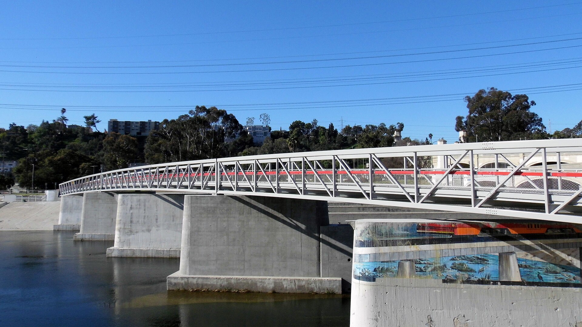


The parklet (or “pocket park”) formerly known as Red Car River Park — dedicated all the way back in 2005 — has been permanently closed as part of the new Glendale-Hyperion Bridge complex. But what the area on the east bank of the Los Angeles River loses in a name, it gains in a brand-new pedestrian bridge that runs alongside the historic Glendale-Hyperion Bridge — the 93-year-old concrete arch bridge viaduct that connects Los Feliz with Atwater, as Hyperion Avenue gives way to Glendale Boulevard.
The new pedestrian bridge (which has yet to receive a proper name) was built atop the concrete footings of a former streetcar bridge, where Pacific Electric's Glendale/Burbank Red Car line ran until 1955 (the concrete replaced a wooden trestle that washed out in 1928). From Silverlake (then "Edendale"), it took passengers through Atwater Village, into Glendale and Burbank, and then back to the Subway Terminal in Downtown LA. Abandoned since the 1950s, the pylons were a haunting reminder of what once was.
But now, they support an entirely brand-new effort to connect both sides of the river (along the Los Angeles River Bike Path) and the communities that surround it. Construction began in April 2019 and the new bridge opened to the public in January 2020. It's open to pedestrians, bicyclists, as well as equestrians and their horses. Enter by foot where Ferncroft Road meets Glendale Boulevard, and keep an eye out for the 2005 mural commissioned by Friends of Atwater Village — “Revisit the Red Car” by artists Rafael Escamilla, Roxanne Salazar and Tom Hinds, which survived the new construction project.


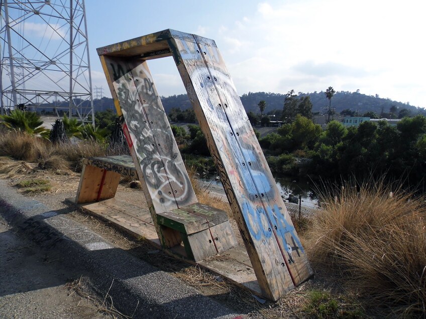
4. Glendale Narrows, Elysian Valley
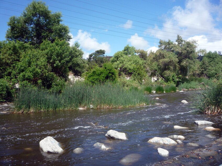


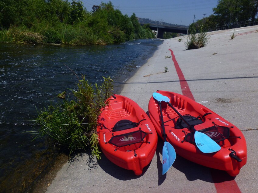


Boy, do we have a river — you just have to know where to look to see it in its natural glory. One section of the Los Angeles River — the "soft bottom" Glendale Narrows — has returned to the wild after the rushing waters broke apart the concrete that had been poured into it to control and channelize floodwaters. There are even fish to catch here, too. And you can bet there are fishermen to catch them.
Although you’ll find some vegetation at the Glendale-Hyperion Bridge section of the river, the “narrows” start south of the Fletcher Drive overpass and start getting really wild under the 2 Freeway. You can access the truly riparian environment through the Lewis MacAdams Riverfront Park, formerly known as Marsh Park and now named after the co-founder of Friends of the L.A. River. Meander downstream to some of the river-adjacent local businesses, like Spoke Bicycle Café.
That’s also where you can get on the water and experience the rapids — yes, rapids! — for yourself. From June 1 through the end of September, you can rent a kayak from the non-profit LA River Kayaks and the proceeds will help support Mountains Recreation Conservation Authority (MRCA), the agency that helps maintain the river’s recreational zone. Or, embark on a guided adventure with LA River Kayak Safari that includes a bike ride to the boat launch and a downstream paddle through the watery “trails” — literally in between trees and over rocks.
5. Rio de Los Angeles State Park/Taylor Yard River Park, Cypress Park


Sandwiched between Elysian Valley, Glassell Park and Cypress Park is one of three California state parks along the Los Angeles River: Rio de Los Angeles State Park, a state recreation area that opened in 2007 and is currently managed in partnership with the City of Los Angeles Department of Parks and Recreation. It’s a project that was first initiated nearly 30 years ago and has become part of the Los Angeles River Revitalization plan to restore 11 miles of the L.A. River between Griffith Park and Downtown Los Angeles.
It was the first parcel of the former 250-acre Taylor Yard to become parkland, but it won’t be the last. In addition to the Bowtie Project (another state park property, see #6 below) farther up-river, there’s also the G2 parcel at the northern portion of the site. G2 is the last remnant of Taylor Yard, which was first established in 1911 on the previous site of grain merchant J. Hartley Taylor’s Feed Mill and eventually taken over as a railyard, freight-switching facility, storage space and maintenance and repair facility by Southern Pacific Railroad, (later Union Pacific Railroad) as well as Metrolink. Industrial use of the site declined starting in the 1960s and ceased altogether in 2006. G2 is slated to open as the 42-acre Taylor Yard River Park in the year 2028, after being purchased by the City of L.A. in early 2017 for $60 million.
In the meantime, the densely populated, underserved communities adjacent to the river — comprised of both industrial and residential areas — can enjoy sports fields, playgrounds, hiking trails, native plants and wildlife viewing at Rio de Los Angeles State Park. A well maintained, unpaved loop winds through the park, extending from the dirt parking lot in the park’s southwest corner up along the existing in-use train tracks and past a landscaped amphitheater. Look for a community-created bench that tells the diverse history of the parkland in mosaic tile — a project of The Greater Cypress Park Neighborhood Council, California State Parks Foundation and The River Project.
6. The Bowtie Project, Glassell Park


Also formerly part of Taylor Yard, The Bowtie Project is an 18-acre post-industrial lot (shaped like a bowtie, pinched in the middle) along the east bank of the L.A. River, on the other side of Glendale Narrows (#4, above). It’s got at least two access points to the river itself, but getting there requires walking up and down the steep concrete channel’s walls. In fact, right now visitors will find minimal amenities at the parcel — aside from some provided fire pits, primitive seating, and lots of art to look at.
California State Parks owns the Bowtie and has partnered with the nonprofit community arts organization Clockshop to activate artist projects, performances, and events at this little-known park, where piles of rubble and rebar remain scattered as reminders of its former use. Since 2014, Clockshop has helped interpret the Bowtie Project as an urban space on the cusp of change through over 90 different executed programs, which also include educational events like Bowtie Storytellers and Writing in Nature, which use the Bowtie as an outdoor classroom.
The Bowtie has not undergone any infrastructural improvements, although an asphalt access road — leftover from the Taylor Yard days — does run the 3/4-mile length of the site. There’s no restroom, running water, lights, or electricity, and no dogs are allowed (aside from service dogs). But go see it now while you can in this state of limbo — with its graffitied roundhouse foundation and other relics still intact, though they might not survive a future park overhaul. Enter where Casitas Avenue ends at Kerr Street and, if no special event is running, park along Casitas or Carrillon Street (without blocking the gate). Otherwise, during an event, you can drive all the way in.
7. The Los Angeles River Center & Gardens, Cypress Park


| Sandi Hemmerlein


Near where the Los Angeles River meets the Arroyo Seco — perhaps known better as where the 5 meets the 110 — you’ll find an entire event center dedicated to the L.A. River. Although it’s frequently rented out for receptions and weddings, it’s worth trying to catch it on an “off” day, even though it doesn’t provide any access to the actual river. But when it’s open (generally weekdays 9 a.m. to 5 p.m.), you can visit a self-guided exhibit that celebrates the 11 miles of “natural” river where plants and animals are not only present, but thriving. Look for it in the California Building on the mission-style grounds.
Park by the big fig tree out front, and walk through the gate of the tall, ivy-covered walls. As you approach the three-tiered fountain in the Main Courtyard, look around at the Early California-style buildings — including one with a bell tower — that surround you. This is where the Santa Monica Mountains Conservancy, now the Mountains Recreation & Conservation Authority (MRCA) opened up its river-focused operations in 1999; nonprofit organizations concerned with “greening” the Los Angeles River have joined the agency there.
But longtime Angelenos may remember the river center as the Lawry's California Center — the condiment company’s corporate headquarters that featured a free tour of the Lawry's Spice packing plant, test kitchen and processing facility. Completed in 1953 with a design by the renowned Stiles O. Clements & Associates firm, it was expanded in 1961 and eventually grew into a complex of restaurants and shops to showcase over 110 of Lawry’s products, including seasonings and sauces. According to a promotional brochure circa 1985, Lawry's California Center was a “secluded oasis” with an “enchanted garden.” A 1991 Los Angeles Times article called it a “hacienda-like hideaway” — and though the Lawry’s operation closed down in 1992 due to lack of business, it still is. And it’s still free to visit — just bring your own snacks.
Bonus: The Great L.A. River Cleanup
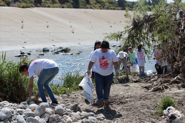
The largest urban river cleanup in the U.S. will take place in 2020 on three separate dates in April — the upper river on the 11, the mid-river on the 18, and the lower river on the 25. Hosted by Friends of the L.A. River, The Great L.A. River Cleanup attempts to show how just one day can make a difference — and has been doing so for 30 years, with last year’s volunteer army consisting of over 6,000 Angelenos.
To participate, choose your location and fill out the online signup form. Certain “hub” locations will also feature a community science BioBlitz hosted by the Natural History Museum of Los Angeles County.


