Where to Discover the Most Unusual Streets in L.A.


Please explore responsibly. While “SoCal Wanderer” continues to uncover the region’s local gems and not-to-miss destinations, these are uncertain times with public health guidelines changing constantly. We encourage our readers to stay curious and cautious.
Los Angeles and its neighboring municipalities have their “celebrity streets” – Hollywood Boulevard, Melrose Place, Rodeo Drive, and the like.
But it’s foolish to think that the story of L.A. can be told only through those major arteries and shopping districts.
Because among the Walk of Fame, the Sunset Strip, and even historic stretches of Route 66, there are oddities among us – lurking within the city grid.
So, whether you’re hoofing it, hopping on a bus, scootering, freewheeling, lowriding, or joyriding, here are five of the best detours where you can gawk at our superlative, history-making, but often little-known streets with BIG character.
1. The Shortest Street (Powers Place, Pico-Union)
If you find yourself between the Victorian mansions of the South Bonnie Brae Tract Historic District and Alvarado Terrace Historic District, don’t blink – or you’ll miss the 13-foot-long brick-paved streetscape known as Powers Place. Certifiably the shortest street in Los Angeles (though it’s wider than it is long), it connects Alvarado Terrace (a street on a terraced hill) with South Bonnie Brae Street at the tip of Alvarado Terrace Park (briefly known as Summerland Park). The tiny strip and its adjacent park were declared a Historic-Cultural Monument (HCM #210) in 1979 and are surrounded by turn-of-the-century homes that are historic landmarks in their own right.
In 1902, the land was subdivided into an exclusive residential tract out of the original Pueblo de Los Angeles. Local resident and then-City Council President Pomeroy Wells Powers advocated for the construction of the park and helped develop the neighboring terrace – building the Gilbert House (at 1333 Alvarado Terrace) and the Powers House (at 1345 Alvarado Terrace), which he resided in with his wife Ida until his death in 1916.
The park was constructed in 1904 – and by 1906, the area was fully developed. But it wasn’t until 1911 that Powers Place got officially designated, named after Pomeroy W. Powers (and not, as a 2006 Los Angeles Times article erroneously reports, in 1910 for contractor Benjamin Powers). And it’s still lined with red bricks, recalling the days when Angelenos got around by horse – and every house on Alvarado Terrace had a hitching post out front.
Brick paving itself is an anomaly in Los Angeles. Until L. Ron Hubbard Way was dedicated in 1996, no streets open to regular traffic had been lined with bricks since the 1930s. However, you can walk on herringbone-patterned brick at St. Vincent’s Court, which is limited to pedestrian traffic and gives you a glimpse of downtown L.A. circa 1907.


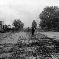

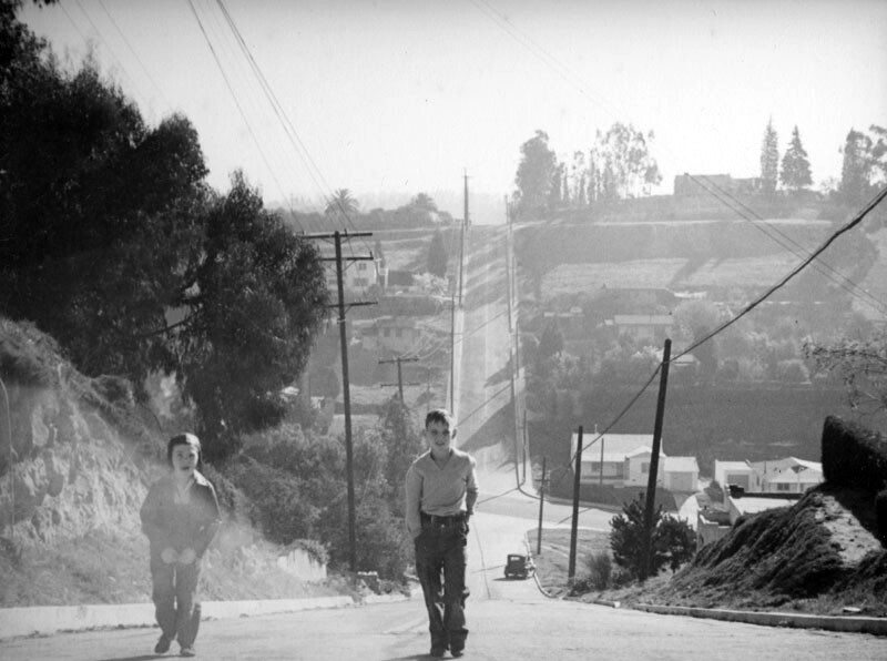
2. The Steepest Street (Eldred Street, Mt. Washington)
Fortunately, the 4800 block of Eldred Street in Mt. Washington doesn’t go anywhere except to the top of Mt. Washington. It dead-ends at the wooden Eldred Stairs – among the city's oldest and longest pedestrian "stair streets" – which connect Eldred Street to another dead end street, Cross Avenue. And that’s probably a blessing – since it rises 33 feet for every 100 feet of length, making it the steepest street in all of California and the third-steepest street in the nation. For many, it’s the 196 stairs that are the main attraction – they’re even featured in “Walk #7” of Charles Fleming’s "Secret Stairs" walking guide. In fact, Eldred Street itself is only 1,240 feet long.
The street is named after D.W. Eldred, a local landowner in the Highland Park Tract, which had been developed by G.W. Morgan out of land belonging to the former Rancho Verdugo. (It was annexed to the City of L.A. in 1895, giving it access to more water.) Many property records still refer to “D.W. Eldred’s Subdivision.” It was – and, in many ways, still is – a place where you could escape the chaos of city life. Built in 1912, it defies the peak of Northeast Los Angeles – and in doing so, it drives away visitors.
Even postal workers won’t make the climb, instead depositing mail in a cluster of mailboxes at the bottom of the hill. Trash collectors dare to drive downsized garbage trucks up the hill once a week. If you decide to venture to the top in a vehicle, prepare to white-knuckle your way through the turnaround at the end, which doesn’t even qualify as a cul-de-sac. And if you’re so bold as to actually exit your car while you’re up there, make sure the ground isn’t slick from rain. Set the emergency brake. Be prepared to not be able to close your car door when you get back in. And know that if you drive something with a high center of gravity, you run the risk of rolling over.


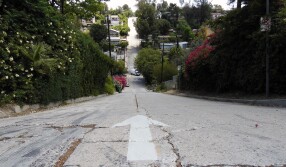
3. The Next-Steepest Street (Baxter Street, Echo Park)
Baxter Street has gotten a lot of media attention as of late, since navigation apps like Waze and GPS systems had sent too many unsuspecting victims either up or down its eye-poppingly steep climbs and dips. Since you can’t see any oncoming traffic as you ascend the hill, each downward slope of Baxter – on either side of the intersection with North Alvarado Street – was redesignated as a one-way street in 2018. (When two-way traffic was allowed, some larger vehicles, like limousines and buses, couldn’t make it over the crest of the hill and got stuck at the crown of its summit.) Stop signs have been added to the previously uncontrolled intersection. But nevertheless, the drive is still harrowing. The only thing worse than experiencing Baxter Street by car is by walking it.
Most L.A. streets clock in at no more than a 15% grade – at least since the rules changed in the 1950s. But at a 32% grade, Baxter is actually tied with 28th Street in San Pedro and its Echo Park neighbor, Fargo Street (which is shorter and broken up into pieces) as the second-steepest street in Los Angeles. That makes it the street with the fifth-steepest grade in the state of California – and still one of the steepest streets in the country. It’s enough to bring vehicular tourists to the area just to experience it from behind the wheel. Experienced, cautious drivers know to respect the street’s power and keep their distance. Masochists like to bust their legs climbing up either side of it. But don’t even think about parking your car on the incline.
Baxter Street was first officially designated by the City of Los Angeles in 1872, but it wasn’t actually built until 1884 when the area was subdivided. There weren’t any motorists back then – and in the decades that followed, Angelenos mostly got around by streetcar, like the Edendale line of the Pacific Electric that ran through present-day Echo Park. Local residents would amble down Baxter Street to hop onto the lines that ran on either side of it – along Echo Park Avenue and Alessandro Street. It’s still a relatively quiet residential neighborhood, with a view of the Silver Lake Reservoir in the distance. If you decide to go gawk for yourself, obey the traffic patterns and posted parking restrictions, and try not to get stuck.


4. The Abandoned Right-of-Way to Self-Realization (Ave 43, Mt. Washington)

Los Angeles & Mt. Washington Incline Railway once connected Yellow Car passengers (on the Los Angeles Consolidated Electric Railway’s “Garvanza” car) to a way up to the top of the Mt. Washington subdivision, high above the streetcar-oriented suburban development now known as Highland Park (then called “The Highlands”). The entire trip up 3,000 feet to the summit (at 940 feet of elevation) would take about eight minutes. And now, you can follow the funicular’s decommissioned and dismantled former path on foot or by automobile.
Venture to the corner of Marmion Way and Avenue 43, look up from the Gold Line tracks, and you’ll spot the original terminus of the railway at the bottom of the mount. That’s where, from 1909 to 1919, patrons would buy a ticket for a ride up on one of the two cable cars that ran up and down, Florence and Virginia. The front façade has changed a bit, the signage removed, large front entrance covered up – but it's the same building, with Spanish tile roof and front-facing balcony. Although it once operated as a market, it’s now a private residence – so enjoy the view from afar.
The road that has been built in its path – Avenue 43 – was most recently paved in 1930, when the tracks of the abandoned railway were removed. As you head up the hill, you’ll reach a section that was once deemed too steep for cars to pass – where Avenue 43 shifts sharply to the right to circumvent the grade, becoming Glenmuir Avenue. The only way to go straight up to the top along Mt. Washington’s western slope is by a public staircase, which joins up with Canyon Vista Drive.
You can walk all the way up Canyon Vista to the top of Mt. Washington – and at San Rafael Avenue, you’ll find the former Mt. Washington Hotel, now the headquarters and administration office for the Self-Realization Fellowship. One of the attractions of the original hotel in the early 1900s was the garden – now a spot for meditation, as you pass through the Temple of Leaves and along manicured pathways and take in the view of today’s modern downtown L.A. skyline.


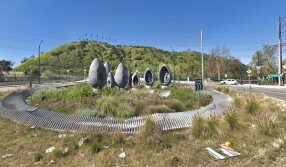
5. The First Roundabout (Riverside Roundabout, Cypress Park)
L.A. got its first modern roundabout – and so far, its only one – just two years ago, in 2017. Sure, we’d had our share of circular streets and mini circles at four-way stops – but at this intersection (known colloquially as the Riverside Roundabout), you could literally drive in circles without stopping, ad infinitum. And thanks to the public art installation known as “Faces of Elysian Valley,” you’d have plenty to keep you entertained as you circle into infinity.
Designed by Greenmeme Studio, the most eye-catching feature is a number of egg-shaped figures – each 8 to 12 feet tall and depicting a face from a member of the local community. Made of locally sourced granite, they were supplied and fabricated by the Minnesota-based quarrier, Coldspring. Besides controlling traffic, the idea behind the roundabout was also to mitigate smog and other environmental pollution and to make this busy thoroughfare a bit more drought-wise. The traffic island (which measures 100 feet in diameter) channels stormwater away from the surrounding streets and captures and stores it in an underground cistern. It’s all solar-powered, too – as is its nighttime lighting scheme.
Find it at the junction of Figueroa Street, Riverside Drive and San Fernando Road by Confluence Park, just past where the 5 freeway crosses over the 110 and a stone’s throw from the confluence of the Los Angeles River and the Arroyo Seco. There are pedestrian crosswalks surrounding the roundabout, but they don’t provide any access to the actual traffic circle. And since there’s no signal control in the circle, you won’t want to make a run for it on foot. An alternative, of course, is to enjoy the public art via one of the bike paths that run through the area.


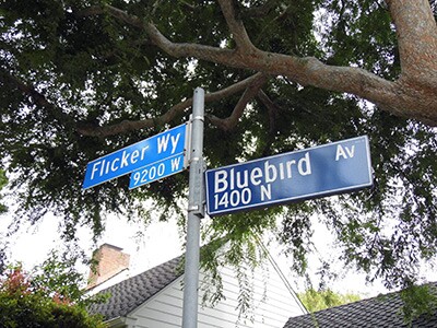
Bonus: The Bird Streets, Hollywood Hills
Nestled above the Sunset Strip, you’ll find a celebrity enclave with some of the quirkiest street names around – including the namesake of the song “Blue Jay Way,” written by George Harrison and recorded by The Beatles for their 1967 Magical Mystery Tour. The track is said to have at least partially inspired Charles Manson’s “Helter Skelter” theory of an impending racial uprising.
It’s actually a subdivision – along with Trousdale Estates – of the former Doheny Estates, the sprawling territory of oil baron Edward L. Doheny. The first of the avian-inspired appellations appeared in 1924, and they continued into the 1960s – just in time to inspire the “Dark Horse.” But most recently in 2017, the single block of Pinto Place, down the road from Thrasher Avenue, got a new ornithological moniker: Hummingbird Place.


