Where to Explore 5 of L.A.’s Great Footbridges


Please explore responsibly. While “SoCal Wanderer” continues to uncover the region’s local gems and not-to-miss destinations, these are uncertain times with public health guidelines changing constantly. We encourage our readers to stay curious and cautious.
Southern California has got some magnificent bridges you can drive across, but sometimes you want to get out of your car — and away from traffic — and make a spectacular crossing on foot.
And that’s where our pedestrian bridges come in.
In Los Angeles alone, we’ve got footpaths that take us across busy streets, freeways, canyons and bodies of water like rivers, lakes and streams.
Some are brand-spanking new, while others are as old as anyone can remember.
And although some footbridges are an absolute necessity to get wherever you’re going, their utility doesn’t have to detract from their beauty.
Here’s where to find five of L.A.’s most scenic bridge crossings — and why they’re fascinating destinations in their own right.
1. Park to Playa Regional Trail Pedestrian Bridge, Baldwin Hills


Until October 2020, there was a gigantic obstacle to connecting the open spaces, trails and parklands of Baldwin Hills: La Cienega Boulevard. This main thoroughfare cuts through the Inglewood Oil Field — with Kenneth Hahn State Recreation Area on the east side and the Stoneview Nature Center and Baldwin Hills Scenic Overlook on the west side. But now, there’s a pedestrian bridge that connects 13 miles of trail from Baldwin Hills all the way out to the Pacific Ocean at Playa del Rey — up and over the traffic zooming by on La Cienega.
The Park to Playa Trail was in the works and under construction for a decade — and the completion of the new 440-foot-long overpass above La Cienega marks the completion of its final segment. A collaborative project between the Baldwin Hills Regional Conservation Authority, Baldwin Hills Conservancy and Los Angeles County Parks and Recreation, the bridge provides a direct path from South L.A. to the beach for pedestrians (with their dogs on a leash), runners, bicyclists and even wildlife — with small critters welcome to scuttle through the native plantings alongside the footpath.
If completing a 13-mile hike isn’t in your near future, you can access the bridge directly from its eastern approach, directly below the Doris Japanese Garden in Kenneth Hahn Park. Look for a narrow driveway marked “Baldwin Hills Parkland” directly east of the Gordon R. Hahn and park in the dirt lot directly adjacent to the bridge entrance. You can also park at Stoneview Nature Center and descend the trail to the bridge’s western approach. For a car-free experience, the Baldwin Hills Parklands Shuttle Bus known as “The Link” also provides transportation from the Metro Expo Line station at La Cienega and Jefferson to both sides of the bridge. It runs every 30 minutes weekends and holidays. Fare is just 25 cents one way.


2. North Atwater Multi-Modal Bridge, Atwater Village


Located in the Atwater Village Equestrian District, there’s a new pedestrian — and equestrian — bridge that spans the Los Angeles River, connecting North Atwater Park on Chevy Chase Drive with the bike path that runs along the 5 Freeway (part of the North Atwater East Bank Riverway project). It’s part of the Los Angeles River Revitalization Master Plan, which dates back to 2007 — but the bridge itself was first proposed all the way back in 1998. It was completed in February 2020.
With its suspension cables and a spire (or “mast”) rising 148 feet above the riverbed, the 325-foot-long steel bridge resembles a sailboat — visible from far upstream and downstream, standing in stark contrast against the hills of nearby Griffith Park. And it’s actually two bridges in one, with horses and their riders getting a dedicated deck, separate from pedestrians and bicyclists. The entire bridge measures 28 feet wide — giving all of those who cross plenty of room.
When you embark on the journey yourself, take your time and have a good look down at the “soft bottom” stretch of the river known as Glendale Narrows. Whether or not you’re an avid birdwatcher, you’re sure to spot some fascinating shorebirds, like egrets and great blue herons, which are known to frequent the waters below.
3. Red Car Pedestrian Bridge, Atwater Village


There’s a new pedestrian bridge that’s been built in the exact spot where Pacific Electric's Glendale/Burbank Red Car line ran until 1955. From Silver Lake (then "Edendale"), it took passengers through Atwater Village, into Glendale and Burbank, and then back to the Subway Terminal in Downtown L.A. Abandoned since the 1950s, several bridge-less concrete pilings stood stoic in the middle of the Los Angeles River. They were a haunting reminder of what once was.
Now, these concrete footings of the former streetcar bridge support a brand-new effort to connect both sides of the river (along the Los Angeles River Bike Path) and the communities that surround it — the Red Car Pedestrian Bridge. Officially dedicated in January 2020 after 16 years of planning and nine months of construction, the new steel-truss bridge is open to pedestrians and bicyclists, as well as equestrians and their horses.
You’ll find it as part of the new Glendale-Hyperion Bridge complex in the former Red Car River Park — where Hyperion Avenue gives way to Glendale Boulevard and connects Los Feliz with Atwater Village. Enter by bike from the established path or by foot where Ferncroft Road meets Glendale Boulevard. No cars (or trains) allowed!
4. Fern Dell, Griffith Park, Los Feliz
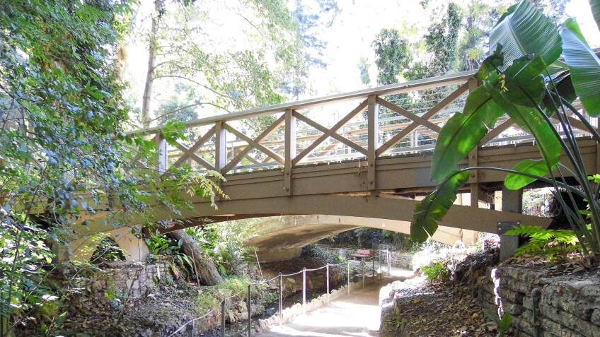
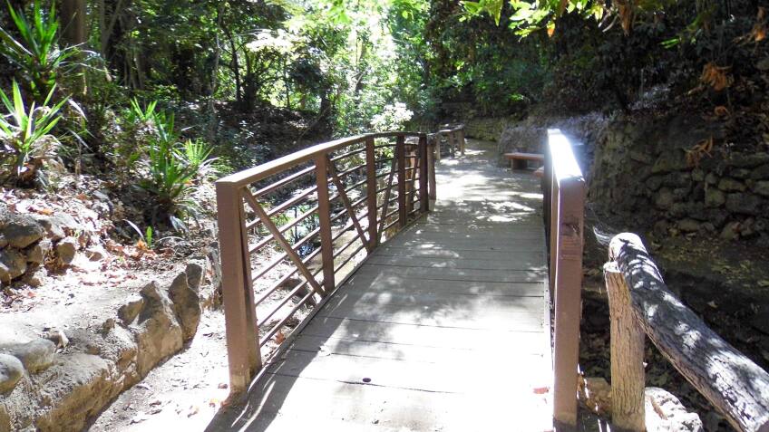
Today, locals and tourists alike may flock to Griffith Park for its observatory, zoo, museum, concert venue and hiking trails that provide clear views of the Hollywood Sign — but in the early 20th century, Griffith Park's real attraction was Fern Dell. In 1914, this shady canyon with a year-round stream was landscaped into a rustic fern garden with terraced pools, bridges, and concrete railings that looked like they were made of logs (a.k.a. faux bois). And it’s still Griffith Park's most accessible — and magical — place.
The closest Metro station is the Red Line at Hollywood/Western (a 0.6 mile walk uphill); the closest bus stop is for the DASH Hollywood line at Franklin and Western Avenue (about a third of a mile walk uphill). Or, park your car anywhere along Fern Dell Drive between Black Oak Drive and Red Oak Drive, where you can enter this fantasy of ferns anywhere there’s a break in the fence on the west side of the road. At Red Oak Drive, you can walk a 52-foot-long pedestrian bridge that runs parallel to the concrete vehicular bridge — and then walk under the bridge to admire its vintage (but restored and reinforced) log beam supports.
In Lower Fern Dell, nine footbridges connect the pathways of the Fern Dell Nature Trail, whose waters are what likely drew Native Americans like the Tongva (a.k.a. Gabrielino tribe) to the Western Canyon of what’s now Griffith Park, now known as Fern Dell Canyon. The tribe’s former council grounds, called Mococahuenga, are located at the Fern Dell entrance and were designated Los Angeles Historic-Cultural Monument #112. Be sure to also look for historic grottos, benches carved out of stone, and a reproduction of a supposed “fountain of youth.”
5. Ballona Lagoon “Lighthouse” Bridge, Venice/Marina del Rey


The Ballona Lagoon pedestrian bridge on the Marina Peninsula is a good place to start exploring the Ballona Lagoon Marine Preserve — named after the Rancho La Ballona Mexican land grant, which also featured the Ballona Creek, Ballona Wetlands and Ballona Bay. Only a fraction of that formerly extensive system of tidal wetlands still exists — and now this environmentally sensitive saltwater estuary habitat (which, unlike the Ballona Creek, hasn’t been channelized) supports a biodiverse ecosystem.
For a car-free experience, the LADOT Commuter Express bus #437 stops right at the closed-spandrel arch-style bridge on Pacific Avenue and Lighthouse Street, just one block from Venice Beach. If you’re driving, you can park your car on the street anywhere on Pacific Avenue between Hurricane Street and Via Marina at the Marina del Rey Harbor Channel (where there are a few metered spots). Start strolling along the public access trail that runs along the western shore of the lagoon, where you can read interpretive signage about the local sensitive plant species (like Orcutt’s yellow pincushion), as well as the marine fishes and shorebirds (like the endangered California least tern) that thrive in and around the ocean-fed waters.
Use the Ballona Lagoon Bridge to cross over the water and reach an unpaved esplanade that runs alongside the lagoon’s east side. Be sure to detour through the charming Marina del Rey neighborhood known as The Silver Strand tract, which is composed of lush and shady walkways such as Lighthouse Mall, Mast Mall and Northstar Mall — but curb your pup, as the residents who maintain the landscaping won’t appreciate any little “gifts” left behind.
Bonus: Venice Canals, Venice


Many of the canals of Abbot Kinney’s “Venice of America” may have been filled in during the late 1920s — but the manmade waterways of this Venetian-style seaside resort haven’t completely disappeared. You can explore some of the remaining canals on foot — including the Grand Canal (which the Ballona Lagoon connects to) and its four pedestrian bridges. Look for more pedestrian-only bridges between Carroll Court and Court D, Linnie Avenue and Howland Canal, and between Holly Court and Sherman Canal.
Top Image: Fern Dell pedestrian bridge | Sandi Hemmerlein


