7 of the Best California Desert Summer Campgrounds


Yes, you can go camping in the desert in the summer. No, you don't have to have a death wish to do so. Even though summer is usually the time of year when the desert is the least hospitable, you can still enjoy staying outdoors in California's arid lands if you do one or more of the following: 1) go north, 2) go uphill, 3) go prepared for heat.
Which isn't to say you should ever go desert camping unprepared for heat (even when camping in the winter). Summer camping in hot places in the desert requires a special kind of preparation, though. You're going to want to bring shade, both the portable kind you wear on your head and the kind you can sit under. You need to bring loose-fitting, light clothing that covers all of you; nothing interferes with your skin's ability to shed heat more than a sunburn. And you'll need to bring a lot of water, and you'll need to make drinking that water the primary physical activity in which you engage.
But if you have something a bit different from sheer endurance in mind, the other two tricks can really help you enjoy summer camping in the desert. Though local conditions can always vary, heading uphill or northward will tend to get you to cooler places. Ambient temperature is generally somewhere between three and five degrees Fahrenheit cooler for every 1,000 feet you gain in elevation, and all other things being equal, you lose about two degrees F for every hundred miles you travel north.
Which means if it's 120° at Sea Level in Coachella, it's entirely possible that someplace like the Ancient Bristlecone Pine area in the White Mountains, 200 miles north and eight or nine thousand feet up, will be down in the comfortable 80s, or even lower.
Following are a few of the best places to find comfortable summer camping in the California desert.


Lava Beds National Monument
Lava Beds National Monument
In what's now California's northeast corner, lava flows from Medicine Mountain over the last half million years have left a network of lava tubes and other volcanic formations for you to explore. The Monument's elevation ranges from 4,000 to 5,700 feet, and all the way at the north end of the state its summer daytime highs generally stay in the 75-80 degree range. And if it gets too hot, you can explore the lava tubes, where the air temperature is usually in the mid-60s.
A developed campground with 43 sites and old-school infrastructure built by the Civilian Conservation Corps in the 1930s is available on a first-come, first-serve basis year round. Drinking water and restrooms are provided.
Interpretive programs are often conducted in an amphitheater near the campground. Aside from the dozens of explorable lava tubes, Lava Beds also contains a world-class petroglyph site and the historic Captain Jack's Stronghold, a natural fortress where the Modoc people held off the U.S. Army for an astonishing six months. Hike through the Stronghold and you'll see how they did it.
Getting there: This is not a day trip. It takes 11 hours or more to get from Los Angeles to Lava Beds, so keep this spot in mind for a longer-than-three-day weekend. Taking Interstate 5 to Weed, heading northeast on US 97, then taking State Route 161 through the Klamath National Wildlife Refuge and following the signs will get you there a few minutes faster, but only a few. Why not head up Route 395 instead? That gives you more time in the desert, and offers the possibility of making a few other spots we mention here part of your trip. Limited supplies are available in the town of Tule Lake.
Mahogany Flat Campground, Death Valley National Park
Tell your friends you're going camping in Death Valley in July. Watch with wry amusement as they struggle for words. And then hie yourself to Death Valley National Park's Mahogany Flat Campground, in the juniper belt of the Panamint Mountains at 8,200 feet above sea level.
About a four hour drive from downtown Los Angeles, Mahogany Flat is a great destination for those weekends that start a little early, so that you can get there before the crowds arrive. Park yourself in the shade of the junipers, help yourself to a tall container of drinking water (and you'll have to bring that water with you, because there's none available in the campground) and just breathe it all in. Or if that seems too sedentary, you can set out on the trail to Telescope Peak's summit, only seven miles away and about another 2,500 feet into the sky. Below you, on the floor of Death Valley proper, temperatures are at least 20 degrees higher.
The campground's 10 first-come, first-serve sites really require a high-clearance vehicle to reach, though you do hear of people making it up there in low-slung rental cars and the like. We can't recommend you try doing that. A standard car will likely make it as far as the charcoal kilns a mile and a half from the campground, so if you don't mind a long, leisurely hike with camping gear you could try parking there and walking in. Or if you're determined to do your desert car-camping in your sedan, you can opt for the Wildrose Campground, which is accessible to motor homes and the like. Depending on where your car is on the spectrum between Mini Cooper and Subaru Forester, the Thorndyke Campground -- at 7,000 feet, a bit lower and warmer than Mahogany Flat --- might be a good compromise.
Getting there: From Ridgecrest, take Trona Road north through its eponymous mining town and into the Panamint Valley, where it becomes Trona-Wildrose Road. 32 miles from downtown Trona, you'll reach a T-intersection with Panamint Valley Road. Keep going straight as Trona-Wildrose Road starts climbing into a narrow canyon up into the Panamint Range. The Mahogany Flat campground is 18.7 miles from the intersection with Panamint Valley Road. Don't forget that you need to bring all the water you'll be using: it's a looong drive back down that road. Limited supplies are available at Panamint Springs and at Stovepipe Wells.
Walker Pass, Pacific Crest Trail
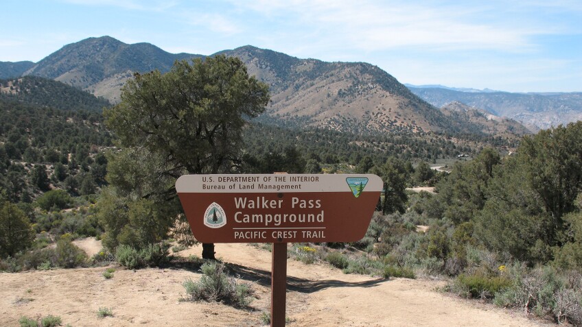
This spot is an unsung beauty, with one exception. At around 5,500 feet with plenty of shade, it can stay reasonably comfortable in summer. There are two free campsites that have parking next to them, and another ten walk-in sites. The ratio is due to the campground's proximity to the Pacific Crest Trail, which is less than a quarter mile uphill. The sites are walk-in spots for thru-hikers. Which doesn't mean you can't take advantage: you just have to lug your stuff a little ways from your parking place.
From this spot, just above Walker Pass, you can see the confluence of several of California's biomes. Desert mixes with Sierra Nevada and Coast Ranges here: you can touch Joshua trees and lodgepole pines and manzanitas all at once without moving your feet. (This area also made my list of the best places to see Joshua trees.) There are piñon pines here, too, and in a good nut year families will come up from Ridgecrest and Bakersfield with rakes and buckets to harvest them.
What's that one exception? There's no water piped into the campground. ordinarily, that wouldn't be a big deal. There are hundreds of great camping places in the desert with no running water. But the lack of water makes it really hard to clean the BLM's concrete pit toilet, which can achieve absolutely nuclear levels of offensiveness depending on how many months its been since they came by with the honey truck and the steam cleaner. Even if it's relatively inoffensive, it's a favorite spot for gatherings of the local bee population.
If that's not a deal-breaker for you, and honestly it is for precisely one half of my household, then the Walker Pass Campground is well worth checking out. It's almost never crowded despite its accessibility, and there are campsites well upwind of the, well, you know. And you get some amazing views of the top of the Kern River drainage, with the arid Scodie Mountains to your east and the granite mounds of the Domeland Wilderness off to the west.
Getting there: Head uphill and to the west on Route 178 from its junction with Route 14 west of Ridgecrest. You'll reach the campground in 9 miles, just past Walker Pass. Don't forget to bring abundant water. And disinfectant.
Mono Lake Jeffrey Pines
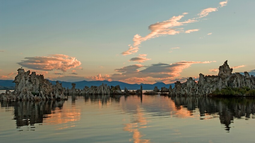
California's oldest lake sits at around 6,400 feet, making it a lot cooler in summer than many desert destinations. The formal campgrounds near Mono tend to get filled up early, what with the world's most popular National Park -- Yosemite -- right next door, but if you head a bit away you can find remarkable and free camping in one of California's most unusual settings: a desert pine forest.
Enough moisture leaks over the Sierra between Mono Lake and Mammoth to support forests of striking Jeffrey pines, an arid-adapted tree that can get really big. By the time you get to Mono Lake from the south you've driven through a good-sized patch of them around Deadman Summit. There are Forest Service campgrounds in the Jeffrey pines near Mammoth, and they're nice ones. But tucked under the Sierra as they are, they don't seem very deserty.
Head east on Route 120 along the south shore of Mono, though, and you find some stands of Jeffrey pines farther from the moist mountains. They grow in sparser, more open stands intermingled with aromatic big sagebrush, and if you play your cards right you can find a spot with a long view through the trees to the lake and the saline desert beyond.
It's all dispersed camping here, and primitive, and so you'll need to bring everything you plan on using: water, a shovel for toilet purposes, and things to keep your mind occupied without cell service. Here's one recommendation: walk up to a big sunwarmed Jeffrey pine, stick your nose into one of the the clefts in its strawberry blonde bark, and inhale deeply. Is that vanilla? Butterscotch? Pineapple? A little of each?
If you bring a camp stove, or a hankering for a campfire, or anything that uses flame including a lantern, you will need a free permit. You can get one at the Mono Lake National Scenic Area visitor center a few miles north of Lee Vining on 395. If hiding in the Jeffrey pines isn't your style, the staff there can recommend other options, including camping in the sagebrush along Rush Creek or bedding down on the former lakebed exposed by DWP's water exports. You'll need permits for most of the dispersed camping options, but hie thee to the Jeffrey pines without need for a fire and you're all set without one.
Getting there: From US 395 five miles south off Lee Vining, take Route 120 east toward Benton. In about 4 miles you'll pass the South Tufa Reserve; another 4 miles past the north end of the Mono Craters and you'll start seeing old logging roads running into open stands of Jeffrey Pines (you can see the transition between sagebrush and pine trees in this Google Street View shot). Explore and find a good spot out of sight of the road traffic.
Mid-Hills, Mojave National Preserve
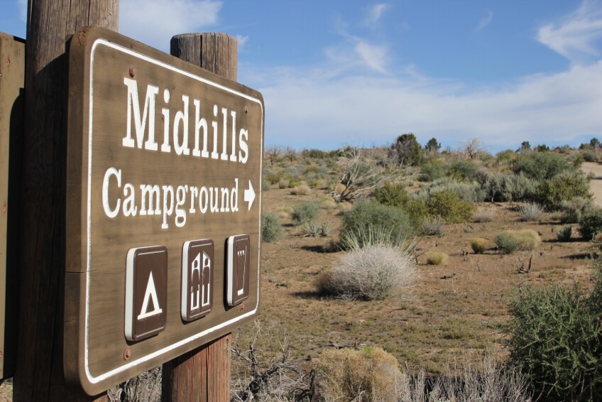
There are two schools of thought regarding the Mid-Hills Campground in the Mojave National Preserve. One school thinks of it as a lovely, medium-altitude respite from the summer heat to be found in the Preserve's lower altitudes. The other school of thought agrees, but adds wistfully that you should have seen it before the summer of 2005, when the catastrophic Hackberry Fire killed the majority of the piñon and juniper forest that had shaded the campground.
Both schools have their points. Mid-Hills was a glorious place before the Hackberry Fire, with chest-high sagebrush and deer and coyotes sleek and fat as pampered German shepherds. But it isn't too bad a place eight years post-fire, either, and about half the campsites still have their original trees in place.
And at around 5,600 feet with northern exposure to the breezes off Cima Dome, Mid-Hills is a bit cooler than the big preserve campground at Hole In The Wall, a thousand feet lower.
Mid-Hills has 26 campsites available on a first-come, first-served basis for $12 a night. Access is via a few miles of dirt road, though the way should be passable for all but the most low-slung vehicles. (The National Park Service doesn't recommend pilots of motorhomes or trailers make the attempt.) Pit toilets, picnic tables, and fire rings are available, as is drinking water. If you're ambitious, you might check out the 8-mile trail between Mid-Hills and Hole In the Wall. Fill your water bottles all the way before you go.
Getting there: From the Essex Road exit on Interstate 40 west of Needles, head north 9.7 miles to Black Canyon road and turn right. Another 9.7 miles will get you to the Hole In The Wall campground: the pavement on Black Canyon Rd. ends not long after. Keep going on a usually well-maintained dirt road for about 6.5 miles from the end of the pavement, until you reach Wild Horse Canyon Road. (If you think you passed Wild Horse Canyon Road already, don't fret: you did. It loops around from Mid-Hills to just south of Hole in The Wall.) Turn left, and proceed about a mile and a half to the Mid-Hills Campground.
Lone Pine Campground, Owens Valley
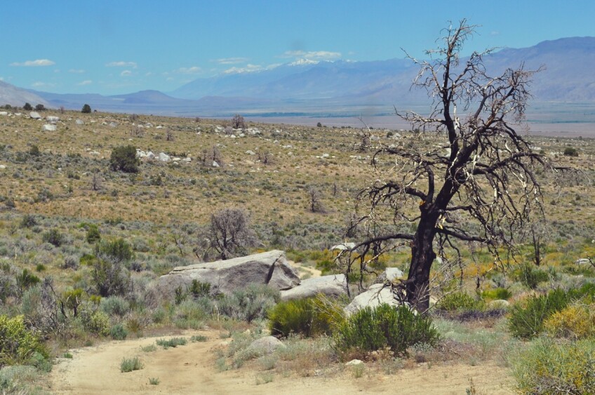
The Owens Valley car-camping experience doesn't get better than this. At 6,000 feet on the sagebrush-covered east slope of Mount Whitney, this campground sits on the bank of Lone Pine Creek, with its band of streamside trees providing shade. You're still in the desert here, and the dust you'll find worked into every bit of your gear after a couple days' stay proves it, but somehow the liquid white noise of the creek makes your mind feel a bit less parched.
Since this is the center of outdoor recreation in the Owens Valley, nestled between Whitney Portal and the Alabama Hills, opportunities for hiking abound. There's a slightly neglected trail just south of the campground that heads toward Mount Whitney and the John Muir Trail, in fact. Or just sit in the campground, read a book, try to catch a fish, and watch the sun set behind 14,505-foot Mount Whitney to the west.
Lone Pine Campground has 43 sites, 28 of which are reservable. Potable water is available.
Getting there: From the town of Lone Pine, head six miles west on Whitney Portal Road. Supplies can be had in Lone Pine proper, or you can head 8 miles uphill and out of the desert to Whitney Portal, where you can also buy a shower to wash off the dust and sagebrush. This is a popular campground: if you find yourself there after all the spots have been claimed, you can ask for guidance at the Interagency Visitor Center south of Lone Pine. Staff there will be able to direct you to other places to camp, and there are a lot of them.
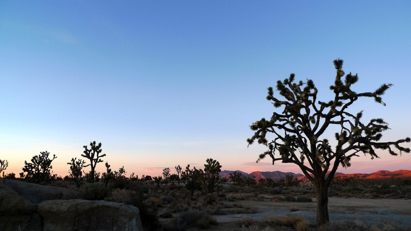
Cima Dome, Mojave National Preserve
I hesitate to share this one: it's my favorite spot in the California desert. Fortunately, the site's absolute lack of amenities makes up for its beauty, and people that'll camp there anyway are likely to be worth meeting.
Cima Dome in the Mojave National Preserve is a big rounded mass of granitic rock about 10 miles across that holds up the world''s largest forest of Joshua trees. (Cima is also on my best places to see Joshua trees list.) At elevations ranging from the 4,000s to the dome's subtle summit a hair above 5,720 feet, this place is well above the worst heat of the desert summer.
Not that it can't get warm. I've enjoyed temperatures well into the triple digits here in summer, on days in which the Joshua trees seem to taunt you with the unfulfilled promise of shade. Sometimes you just have to sit under your tarp, drink more water than you ever thought possible, and at least figuratively chill out, if the literal kind isn't possible.
But temperatures here usually do stay in the civilized double digits, and on days when the thermometer in Baker (if it's working) is reading 103°, you can find yourself soaking up the relatively cool 87° or so atop Cima Dome.
The downside is that you're on your own. There's no water here. There are no toilet facilities. There's no number of campsites, nor any handy roadside kiosk with a Preserve ranger to guide you. The Preserve allows dispersed camping in places that have clearly been used for the purpose before, but the most obvious such -- at Sunrise Rock, home of the controversial Mojave Cross -- are increasingly overrun with people for whom desert solitude and silence are apparently things to be shattered whenever possible.
Fortunately, Sunrise Rock isn't the only option. A network of passable dirt roads covers the Dome, many of them with fine campsites. Ask for a map at the Kelso Depot visitor center in the Preserve so that you don't inadvertently choose a road that's been closed for wilderness preservation purposes, and then do a little exploring.
You will need to bring everything: water, toilet supplies, a place to sit, and your own shade. Once you're off the pavement at Cima Road, a high-clearance vehicle is a must. And unless you're in the burgeoning campers' slum at Sunrise Rock, you will need to be able to find your way back out with no help if something goes wrong, like a flat tire or a busted radiator. Which just makes the place that much better.
Getting there: From Interstate 15, take the Cima Road exit 25.6 miles east of Baker. Head south past the gas station, which has extremely limited supplies, but at least it's open reliably. Sunrise Rock is about 11 miles south of the freeway, near the trailhead for the Teutonia Peak trail, but the dirt roads leading off to potential campsites start well before you get that far. Aside from the gas station on Cima road, limited supplies may be available at the Cima Store, but dont count on them being open. The Nipton Trading Post, 25 miles northeast, is more reliable, and the assortment of stores in Baker a bit more so. Your best bet for a long say is to hit a supermarket in Barstow or Vegas before you head out.


